SJ8397 : The drained Rochdale Canal
taken 6 years ago, near to Rusholme, Manchester, England
The Deansgate Locks (#90 and #91 on the Rochdale Canal) are two of the "Rochdale Nine". When the rest of the Rochdale Canal was closed to navigation in 1952, these nine locks which link the Ashton and Bridgewater Canals, through the centre of Manchester, were the only part of the canal to remain open, forming part of the "Cheshire Ring".
By 1965 the nine locks through Manchester city centre, including locks 90 and 91 were almost unusable. The Rochdale Canal Society was formed to promote the restoration of the canal and in the 1980s and 1990s small scale work began to re-open stretches of the canal. In July 2002, the whole canal became navigable once again, almost 200 years after its original opening.
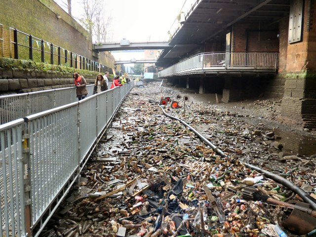
In November 2017, the Canal & River Trust, who now maintain the waterway, drained the locks and the pool between them in order to carry out restoration and repair work to the lock gates and chamber. Part of this involved closing the towpath and installing a temporary walkway This also provided the opportunity to open the locks to the public over the weekend of 2nd/3rd December.
The Rochdale Canal runs for 33 miles between Manchester and Sowerby Bridge in West Yorkshire, UK. In Sowerby Bridge it connects with the Calder and Hebble Navigation. In Manchester it connects with the Ashton and Bridgewater Canals.
The canal was opened between Sowerby Bridge and Todmorden and from Manchester to Rochdale in 1799 and between Todmorden and Rochdale in 1805. Most of the canal was closed in 1952. Restoration work began in late 1980s and by 1996 the canal was opened to navigation once again between Sowerby Bridge and the summit level. The canal was re-opened to navigation along its entire length in July 2002 and forms part of the South Pennine Ring.
Link
 Map © Crown Copyright")
- Grid Square
- SJ8397, 2677 images (more nearby 🔍)
- Photographer
- Gerald England (more nearby)
- Date Taken
- Saturday, 2 December, 2017 (more nearby)
- Submitted
- Friday, 8 December, 2017
- Subject Location
-
OSGB36:
 SJ 8355 9755 [10m precision]
WGS84: 53:28.4652N 2:14.9583W - Camera Location
-
OSGB36: SJ 8356 9755
- View Direction
- West-northwest (about 292 degrees)