2018
ST7669 : WWII Somerset: a walk around the airfield of RAF Charmy Down (1)
taken 6 years ago, near to Upper Swainswick, Bath And North East Somerset, England
WWII Somerset: a walk around the airfield of RAF Charmy Down (1)
-
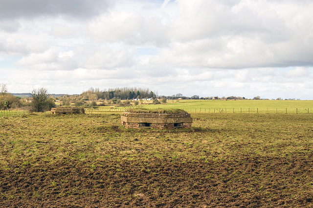
A general view of RAF Charmy Down as it looks today with in the foreground two of the three pillboxes that formed part of the defences on the south side of the airfield. In the far distance on the horizon and to the right of the pillboxes is the former airfield control tower.
Originally planned as a satellite airfield of nearby RAF Colerne, by 1940 when construction began it had become a sector station of No. 10 Group. The airfield opened in 1941 whose first occupants were No. 87 Squadron operating Hawker Hurricane night fighters. Several other squadrons of the RAF followed, all involved in night fighting roles with a variety of aircraft. Hardened sleeping shelters for the aircrew still exist in some of the dispersal areas. In 1943 the station briefly became an OTU for Spitfires before the airfield was turned over to the USAAF in November 1943.
Postwar the airfield was returned to the RAF, and despite little flying taking place, it was not officially closed until October 1946. In the 1950s Charmy Down was one of the stations selected for the Cold War ROTOR radar system, although only preparatory work was ever completed. The site was then abandoned after the not inconsiderable sum of £200,000 had been expended (over £3 million today). Some of the buildings that were built as part of this system are among the remains that can still be seen today.
ST7669 : WWII Somerset: a walk around the airfield of RAF Charmy Down - pillbox #1 (2)
 Map © Crown Copyright")
TIP: Click the map for more Large scale mapping
- Grid Square
- ST7669, 38 images (more nearby 🔍)
- Photographer
- Mike Searle (more nearby)
- Date Taken
- Monday, 12 February, 2018 (more nearby)
- Submitted
- Wednesday, 14 February, 2018
- Subject Location
-
OSGB36:
 ST 7640 6950 [10m precision]
WGS84: 51:25.4408N 2:20.4487W - Camera Location
-
OSGB36: ST 7645 6948
- View Direction
- West-northwest (about 292 degrees)