J3674 : Nos 28-40 Upper Newtownards Road, Belfast - February 2018(2)
taken 6 years ago, 3 km from Belfast, Co Antrim, Northern Ireland
I have no connection with the property or the agents.
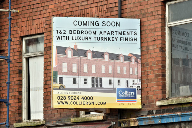
Premises on the northern side of the Upper Newtownards Road, between the Holywood Arches and Grampian Avenue advertised for sale as a redevelopment opportunity and described by the agent as The property comprises three former commercial premises fronting onto the Upper Newtownards Road. The entire site extends to approximately 0.08 acres. . . . . Full planning permission has been granted for the demolition of the existing buildings and construction of three retail units on the ground floor with 8 no. apartments above on the first and second floors. They seem to have been built as houses circa 1918.
The photographs submitted by me appear as a matter of geographical and historical record only. I have no connection with any of the parties involved in the sale.
![Creative Commons Licence [Some Rights Reserved]](https://s1.geograph.org.uk/img/somerights20.gif)
|
· Find out How to reuse this image ·
Share:
|
|||||
| Start a discussion on J3674 | Suggest an update to this image | Contact the contributor | |||
- Grid Square
- J3674, 822 images (more nearby
 )
)
- Photographer
- Albert Bridge (find more nearby)
- Date Taken
- Sunday, 18 February, 2018 (more nearby)
- Submitted
- Sunday, 18 February, 2018
- Geographical Context
- Place (from Tags)
- Subject Location
-
Irish:
 J 366 741 [100m precision]
WGS84: 54:35.8486N 5:53.2227W - Camera Location
-
Irish: J 366 741
- View Direction
- North-northwest (about 337 degrees)
Other Tags