J3674 : No 6 Dundela Avenue, Belfast (April 2018)
taken 6 years ago, 3 km from Belfast, Co Antrim, Northern Ireland
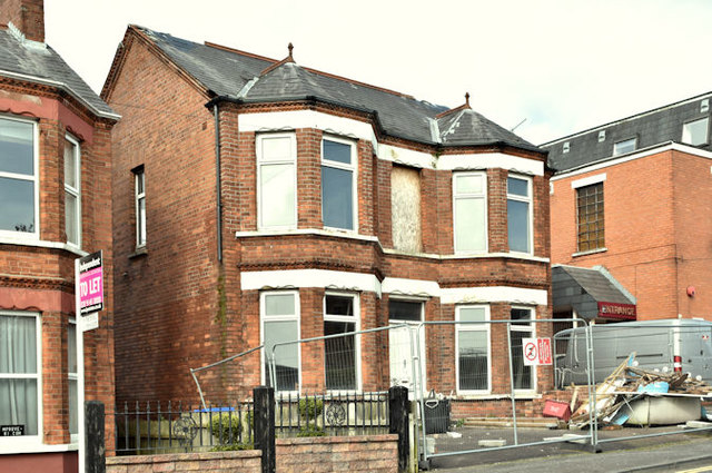
No 6 Dundela Avenue, Belfast (April 2018)
Now fenced off and looking as if internal clearance is underway.
No 6 Dundela Avenue, Belfast
A vacant detached house, once known as Seaforth, built towards the end of the 19th century There is the following planning permission (8 September 2017) LA04/2017/0477/F Change of use from dwelling to 4 apartments. First and second storey rear extension. Elevation changes and associated works involving erection of fence and rear patio. 6 Dundela Avenue Belfast BT4 3BQ.
I have no connection with the property and cannot enter into correspondence.
![Creative Commons Licence [Some Rights Reserved]](https://s1.geograph.org.uk/img/somerights20.gif)
|
· Find out How to reuse this image ·
Share:
|
|||||
| Start a discussion on J3674 | Suggest an update to this image | Contact the contributor | |||
Loading map... (JavaScript required)
- Grid Square
- J3674, 822 images (more nearby
 )
)
- Photographer
- Albert Bridge (find more nearby)
- Date Taken
- Tuesday, 17 April, 2018 (more nearby)
- Submitted
- Tuesday, 17 April, 2018
- Geographical Context
- Place (from Tags)
- Primary Subject of Photo
- Subject Location
-
Irish:
 J 369 744 [100m precision]
WGS84: 54:35.9718N 5:52.8728W - Camera Location
-
Irish: J 369 744
- View Direction
- North-northeast (about 22 degrees)
Other Tags
This page has been viewed about 144 times.
View this location:
KML (Google Earth) ·
Google Maps ·
Bing Maps ·
Geograph Coverage Map ·
More Links for this image
·
Bing Maps ·
Geograph Coverage Map ·
More Links for this image