J3673 : Nos 211-217 Beersbridge Road, Belfast - June 2018(1)
taken 6 years ago, near to Belfast, Co Antrim, Northern Ireland
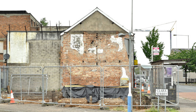
Nos 211-217 Beersbridge Road, Belfast - June 2018(1)
The fenced site with some work done on the foundations - Beersbridge Road is on the right.
Nos 211-217 Beersbridge Road, Belfast
A cleared site, at the corner of Clara Street, with the following planning permission (27 November 2017) LA04/2016/1917/F Provision of 6 apartments (Social Housing) 3No. 2P1B general needs dwellings and No. 1P1B general needs dwellings, ancillary accommodation and amenity. 211-217 Beersbridge Road Belfast BT5 4RR.
![Creative Commons Licence [Some Rights Reserved]](https://s1.geograph.org.uk/img/somerights20.gif)
|
· Find out How to reuse this image ·
Share:
|
|||||
| Start a discussion on J3673 | Suggest an update to this image | Contact the contributor | |||
Loading map... (JavaScript required)
- Grid Square
- J3673, 309 images (more nearby
 )
)
- Photographer
- Albert Bridge (find more nearby)
- Date Taken
- Friday, 15 June, 2018 (more nearby)
- Submitted
- Friday, 15 June, 2018
- Geographical Context
- Place (from Tags)
- Primary Subject of Photo
- Subject Location
-
Irish:
 J 361 735 [100m precision]
WGS84: 54:35.4959N 5:53.7144W - Camera Location
-
Irish: J 361 735
- View Direction
- West-northwest (about 292 degrees)
Other Tags
This page has been viewed about 67 times.
View this location:
KML (Google Earth) ·
Google Maps ·
Bing Maps ·
Geograph Coverage Map ·
More Links for this image
·
Bing Maps ·
Geograph Coverage Map ·
More Links for this image