TR0434 : Benchmark, Church of St Peter and St Paul
taken 6 years ago, near to Bilsington, Kent, England
Grade II* listed.
The Domesday book of 1086 lists the church in Bilsington. The church stands on a promontory with excellent views of Romney Marsh. It is currently accessed through a farmyard.
The moat of Bilsington Manor is nearby.
The church was cared for by the ordained monks of the nearby Saint Augustines Priory until the Reformation in 1535.
The church underwent major repairs in the late 16th century having been described as a ruin in the archdeacons report of 1573. There is a monument on the West of the tower dated 1590 which bears the arms of Sir Martin Barnhum of Hollingbourne who was Lord of the Manor Bilsington.
The church has a 12th century nave and chancel, with a 16th century tower. It was restored in 1883, and is built with ragstone and redbrick with the timbered South porch and plain tiled roof. There is a shingled tower upper stage and pyramidal roof.
There is a 16th century south porch, and the inner door has a stoup on the right. There is a blocked Norman window above the door.
The tower arch dates from the 12th century.
The nave has 19th century decorated-style windows to the south, and 14th century windows to the north.
The roof has three 19th-century crown posts.
The original building, which consisted of the current nave, was extended in the Early English period, and like many churches the chancel is not quite aligned with the nave.
There is a sedilia and piscina. The Rood screen was removed in the 19th century, as was the old musicians Gallery and organ. The current organ came from Sussex in 1952.
There is a medieval octagonal font by the South door.
Outside the church hangs a 15th century bell, taken down from the tower when the bell frame became too weak to hold more than one bell. The bell is older than the tower.
The church was repaired in 2008 including re-roofing the chancel, nave and porch, and replacing the shingles on the tower.
Bilsington is a village in the Ashford district of Kent. The village is about 5 miles south of Ashford, on the B2067 road, Hamstreet to Hythe road north of the Royal Military Canal. The Bilsington Monument (Cosway Monument)is on the edge of the village. The village has a norman church, pub and cricket club.
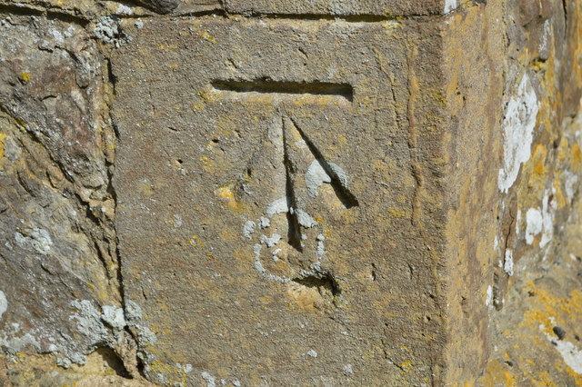
The term benchmark, originates from the chiselled horizontal marks that surveyors made in stone structures, into which an angle-iron could be placed to form a "bench" for a levelling rod, thus ensuring that a levelling rod could be accurately repositioned in the same place in future. These marks were usually indicated with a chiselled arrow below the horizontal line.
The height of a benchmark is calculated relative to the heights of nearby benchmarks in a network extending from a fundamental benchmark, a point with a precisely known relationship to the level datum of the area, typically mean sea level. The position and height of each benchmark is shown on large-scale maps.
 Map © Crown Copyright")
- Grid Square
- TR0434, 106 images (more nearby 🔍)
- Photographer
- N Chadwick (more nearby)
- Date Taken
- Friday, 6 April, 2018 (more nearby)
- Submitted
- Monday, 9 July, 2018
- Subject Location
-
OSGB36:
 TR 0420 3425 [10m precision]
WGS84: 51:4.2745N 0:54.8015E - Camera Location
-
OSGB36: TR 0420 3425
- View Direction
- EAST (about 90 degrees)