J3474 : The "Nambarrie" site, Belfast (August 2018)
taken 6 years ago, near to Belfast, Co Antrim, Northern Ireland
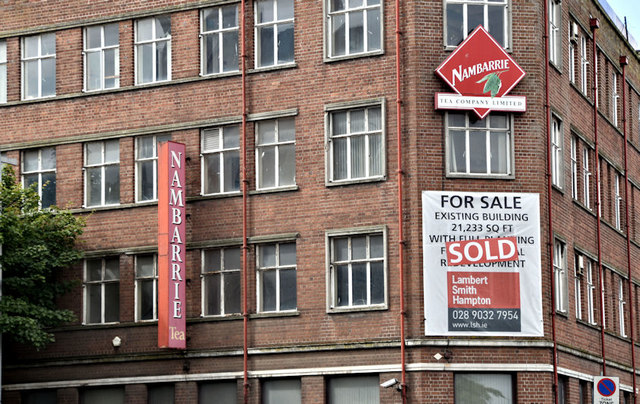
A building, at the corner of Victoria Street and Waring Street, formerly the Nambarrie tea-blending warehouse. The first application for planning permission read 0486/F 21-23 Victoria Street, 45-51 Waring Street, Belfast. Demolition of existing 4 storey building and erection of new 8 storey building comprising 56No. small unit/studio apartments and commercial use at ground floor. A second, on 2 September 2011 , read 0486/F 21-23 Victoria Street 45-51 Waring Street Belfast Demolition of existing 4 storey building and erection of new 8 storey building comprising 56No. small unit/studio apartments and commercial use at ground floor (amended scheme).
A revised application was advertised in mid-February 2013: 0486/F 21-23 Victoria Street 45-51 Waring Street Belfast Demolition of existing 4 storey building and erection of new 7 storey building comprising 56No. small unit/studio apartments and 2no. retail units at ground floor (Amended plans).
The Planning Service website (28 June 2013) discloses that the Belfast City Council schedule of 20 June 2013 records a recommendation for approval.
![Creative Commons Licence [Some Rights Reserved]](https://s1.geograph.org.uk/img/somerights20.gif)
|
· Find out How to reuse this image ·
Share:
|
|||||
|
There are 4 posts in a
discussion on J3474 (preview on the left) |
Suggest an update to this image | Contact the contributor | |||
- Grid Square
- J3474, 4349 images (more nearby
 )
)
- Photographer
- Albert Bridge (find more nearby)
- Date Taken
- Wednesday, 8 August, 2018 (more nearby)
- Submitted
- Thursday, 9 August, 2018
- Geographical Context
- Place (from Tags)
- Primary Subject of Photo
- Subject Location
-
Irish:
 J 341 745 [100m precision]
WGS84: 54:36.0877N 5:55.5132W - Camera Location
-
Irish: J 341 746
- View Direction
- Southwest (about 225 degrees)
Other Tags