N5170 : Fore Abbey
taken 6 years ago, near to Fore, Co Westmeath, Ireland
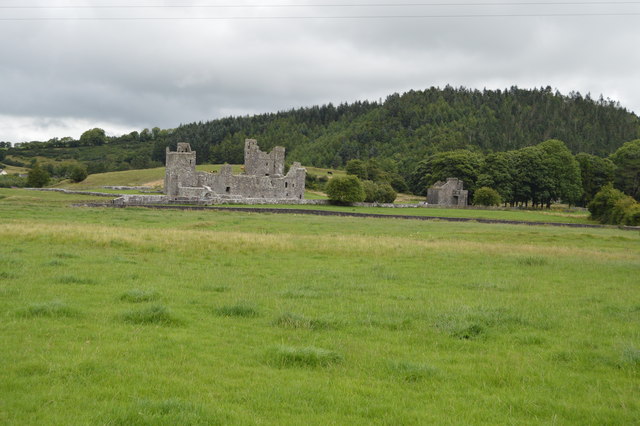
Founded in 630 by St Feichin.
In the 13th century Hugh de Lacy, Lord of Meath built the Bendictine priory in the valley. Many of the buildings that remain today (in ruins) are from the 15th century and have been restored throughout this century, making Fore Abbey the largest Benedictine remains in Ireland. This priory was dedicated to both St Feichin and St Taurin, the Évreux, Normandy abbot of the parent monastery. The abbey is a national monument.
Fore (Irish: Baile Fhobhair, meaning "Townland of the Spring") is a village, next to the old Benedictine Abbey ruin of Fore Abbey, situated to the north of Lough Lene in County Westmeath.
The village, is situated within a valley between two hills: the Hill of Ben, the Hill of Houndslow, and the Ankerland rise area. There can be found the ruins of a Christian monastery, abbey, church, gates and crosses
Fore is the anglicised version of the Irish name that signifies the town of the water-springs and was given to the area after Saint Feichins spring or well, which is next to the old church a short distance from where the ruined monastery still stands. It was St. Feichin who founded the ancient Fore Abbey around 630.
A National Monument in the Republic of Ireland is a structure or site, the preservation of which has been deemed to be of national importance and therefore worthy of state protection. If the land adjoining the monument is essential to protect it, this land may also be protected.
A list of the monuments can be found at Link
![Creative Commons Licence [Some Rights Reserved]](https://s1.geograph.org.uk/img/somerights20.gif)
|
· Find out How to reuse this image ·
Share:
|
|||||
| Start a discussion on N5170 | Suggest an update to this image | Contact the contributor | |||
- Grid Square
- N5170, 17 images (more nearby
 )
)
- Photographer
- N Chadwick (find more nearby)
- Date Taken
- Thursday, 2 August, 2018 (more nearby)
- Submitted
- Sunday, 16 September, 2018
- Geographical Context
- Subject Location
-
Irish:
 N 511 707 [100m precision]
WGS84: 53:41.0271N 7:13.6052W - Camera Location
-
Irish: N 510 705
- View Direction
- Northeast (about 45 degrees)