2018
TQ4180 : Silvertown: Thames Barrier Park: The Green Dock (1)
taken 6 years ago, near to London City Airport, Newham, England
Silvertown: Thames Barrier Park: The Green Dock (1)
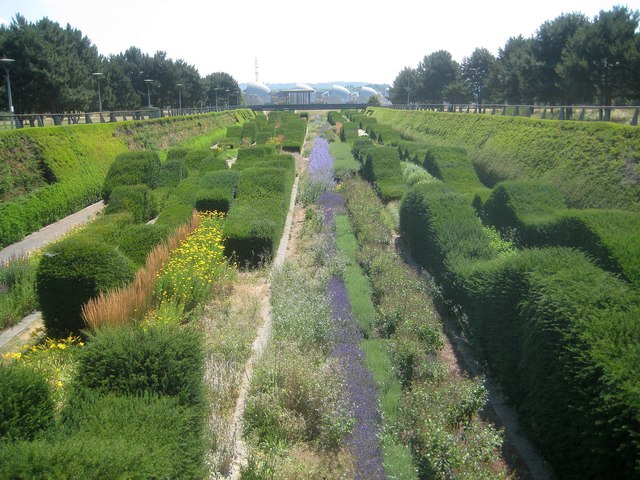
The Thames Barrier Park is a 7 hectare public green space that is managed by the Greater London Authority. When it was opened in November 2000 it was Londons largest new riverside park for over 50 years. It was designed by landscape architect Allain Provost of Groupe Signes of Paris and architects Patel Taylor of London. The park was created on a site that once housed petrochemical and acid works on the Thames riverbank. The contaminated soil was covered with a 6 foot layer of crushed concrete to protect the new soil laid on top.
This part of the park is the 'Green Dock', an approximate 220 metre long sunken garden running diagonally through the park that is intended as a reminder of the site's dockland heritage. It is crossed by two bridges, the other one of which is in the distance and is in grid square TQ4179.
This part of the park is the 'Green Dock', an approximate 220 metre long sunken garden running diagonally through the park that is intended as a reminder of the site's dockland heritage. It is crossed by two bridges, the other one of which is in the distance and is in grid square TQ4179.
 Map © Crown Copyright")
TIP: Click the map for more Large scale mapping
- Grid Square
- TQ4180, 383 images (more nearby 🔍)
- Photographer
- Nigel Cox (more nearby)
- Date Taken
- Friday, 13 July, 2018 (more nearby)
- Submitted
- Wednesday, 10 October, 2018
- Subject Location
-
OSGB36:
 TQ 4121 8000 [10m precision]
WGS84: 51:30.0782N 0:1.9833E - Camera Location
-
OSGB36: TQ 4119 8004
- View Direction
- South-southeast (about 157 degrees)