R0492 : The Cliffs of Moher looking north
taken 6 years ago, 5 km NNW of Liscannor, Co Clare, Ireland
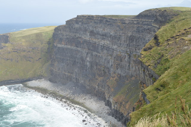
Billed as Irelands most visited natural attraction, the Cliffs of Moher are a 5 mile stretch of almost sheer cliffs consisting of bands of sandstone, siltstone, mudstone and shale rising to a maximum height of over 700 feet. They take their name from a former fort called Moher (or Mhothair) which stood on the Hags Head, at the southern end of the line of cliffs, but which was demolished in 1808, during the Napoleonic Wars, to be replaced by the signal tower that now stands there. Near the highest point stands OBriens Tower, built in 1835 by Cornelius OBrien as a viewing point for tourists.
The Burren and Cliffs of Moher Geopark is an internationally designated area of geological interest in County Clare. It was the third Geopark to be designated in Ireland, and is recognised at both European and global levels. It is sometimes branded as "the Burren and Cliffs of Moher Global UNESCO Geopark."
The Burren comprises dramatic glaciated karst landscapes on Irelands Atlantic coast which have been fashioned in a variety of limestones, sandstones and siltstones originating during the Carboniferous period. The nearby Cliffs of Moher are vertical sandstone and shale sea-cliffs, the highest in Europe, which rise to a height of over 200m in places and which have long drawn sightseers to the area.
![Creative Commons Licence [Some Rights Reserved]](https://s1.geograph.org.uk/img/somerights20.gif)
|
· Find out How to reuse this image ·
Share:
|
|||||
| Start a discussion on R0492 | Suggest an update to this image | Contact the contributor | |||
- Grid Square
- R0492, 135 images (more nearby
 )
)
- Photographer
- N Chadwick (find more nearby)
- Date Taken
- Tuesday, 31 July, 2018 (more nearby)
- Submitted
- Tuesday, 30 October, 2018
- Geographical Context
- Subject Location
-
Irish:
 R 041 927 [100m precision]
WGS84: 52:58.6080N 9:25.6311W - Camera Location
-
Irish: R 039 923
- View Direction
- North-northeast (about 22 degrees)