1999
SJ7207 : Nedge Hill, Stirchley - RAF wartime HFDF Station (4)
taken 25 years ago, near to The Wyke, Shropshire, England
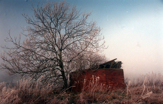
Nedge Hill, Stirchley - RAF wartime HFDF Station (4)
Taken January 1999. Showing the remains of the wooden tower dumped unceremoniously into the confined space of the outer octagonal brick blast wall. A firefighter from Tweedale fire station recalls that the tower was vandalised in the 1970s when an attempt was made to burn it down. At that time it still stood at full height, and was, and still is, recorded on OS maps, as are the outbuildings, of which no trace of either remains today.
SJ7207 : Nedge Hill, Stirchley - RAF wartime HFDF Station (5)
SJ7207 : Nedge Hill, Stirchley - RAF wartime HFDF Station (5)
 Map © Crown Copyright")
TIP: Click the map for more Large scale mapping
- Grid Square
- SJ7207, 32 images (more nearby 🔍)
- Photographer
- Mrs Bess Edwards (more nearby)
- Contributed by
- Mike Searle (more nearby)
- Date Taken
- January 1999 (more nearby)
- Submitted
- Monday, 5 November, 2018
- Subject Location
-
OSGB36:
 SJ 7201 0745 [10m precision]
WGS84: 52:39.8422N 2:24.9176W - Camera Location
-
OSGB36: SJ 7201 0745