2018
TL8078 : Bat bridge over A11
taken 6 years ago, near to Elveden, Suffolk, England
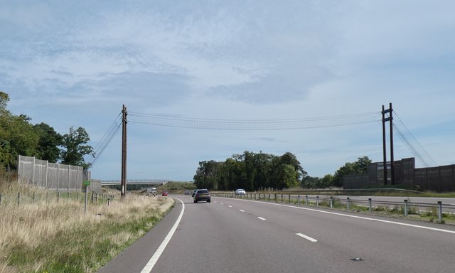
Bat bridge over A11
This bat bridge provides a replacement for the woodland destroyed by the construction of the A11. There are belts of woodland TL8078 : Badgehill Slips on either side of the road, so this gives a continuous line for echo location across the road
A11 Road
The A11 is a major road in Eastern England. It runs roughly north east for 111 miles from London to Norwich, With the M11 opening in the 1970s and then the A12 extension in 1999, a lengthy section has been downgraded between the suburbs of east London and the north-west corner of the county of Essex. It also overlaps with the A14 on the Newmarket bypass.
Link
 Map © Crown Copyright")
TIP: Click the map for more Large scale mapping
- Grid Square
- TL8078, 17 images (more nearby 🔍)
- Photographer
- David Smith (more nearby)
- Date Taken
- Sunday, 16 September, 2018 (more nearby)
- Submitted
- Sunday, 18 November, 2018
- Subject Location
-
OSGB36:
 TL 8069 7886 [10m precision]
WGS84: 52:22.6781N 0:39.1906E - Camera Location
-
OSGB36: TL 8066 7882
- View Direction
- North-northeast (about 22 degrees)