V3968 : Roadsign at St Finan's Bay
taken 6 years ago, near to Keel, Co Kerry, Ireland
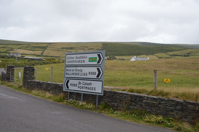
The Skellig Ring Scenic Drive is without doubt the best section of the world famous Ring of Kerry Scenic Drive and Wild Atlantic Way along the Skellig Coast in the south west of Ireland. The unmissable Skellig Ring scenic drive starts in either Cahersiveen or Waterville depending on where you are on the Ring of Kerry and takes in awe inspiring views of the Skellig Islands at every turn, the wonderful Valentia Island accessed by ferry and bridge, the picturesque fishing village of Portmagee, Ballinskelligs with its great Blue Flag beach,
The R566 runs 12km from Derreen to Portmagee.
The Ring of Kerry is a 179-kilometre-long circular tourist route in County Kerry. Clockwise from Killarney it follows the N71 to Kenmare, then the N70 around the Iveragh Peninsula to Killorglin passing through Sneem, Waterville, Cahersiveen, and Glenbeigh before returning to Killarney via the N72.
The Wild Atlantic Way is a tourist trail on the west coast, and on parts of the north and south coasts, of Ireland. The 2,500 km (1,553 mile) driving route passes through nine counties and three provinces, stretching from County Donegal's Inishowen Peninsula in Ulster to Kinsale, County Cork, in Munster, on the Celtic Sea coast.
The route is broken down into 5 sections.
County Donegal
County Donegal to County Mayo
County Mayo to County Clare
County Clare to County Kerry
County Kerry to County Cork
Along the route there are 157 discovery points, 1,000 attractions and more than 2,500 activities. The route was officially launched in 2014.
Website: Link
![Creative Commons Licence [Some Rights Reserved]](https://s1.geograph.org.uk/img/somerights20.gif)
|
· Find out How to reuse this image ·
Share:
|
|||||
| Start a discussion on V3968 | Suggest an update to this image | Contact the contributor | |||
- Grid Square
- V3968, 21 images (more nearby
 )
)
- Photographer
- N Chadwick (find more nearby)
- Date Taken
- Sunday, 29 July, 2018 (more nearby)
- Submitted
- Thursday, 10 January, 2019
- Geographical Context
- Subject Location
-
Irish:
 V 390 685 [100m precision]
WGS84: 51:50.7903N 10:20.1816W - Camera Location
-
Irish: V 390 685
- View Direction
- North-northeast (about 22 degrees)