T1296 : The Cathedral
taken 6 years ago, near to Laragh, Co Wicklow, Ireland
This is 1 of 4 images, with title The Cathedral in this square
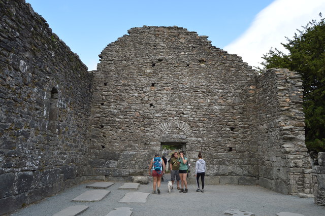
The Cathedral
The largest and most imposing of the buildings at Glendalough, the cathedral had several phases of construction, the earliest, consisting of the present nave with its antae. The large mica-schist stones which can be seen up to the height of the square-headed west doorway were re-used from an earlier smaller church. The chancel and sacristy date from the late 12th and early 13th centuries. The chancel arch and east window were finely decorated, though many of the stones are now missing. The north doorway to the nave also dates from this period. Under the southern window of the chancel is an ambry or wall cupboard and a piscina, a basin used for washing the sacred vessels. A few metres south of the cathedral an early cross of local granite, with an unpierced ring, is commonly known as St. Kevin's Cross
Glendalough Monastic Site
An Early Medieval monastic settlement founded in the 6th century by St Kevin.
Wikipedia: Link
National Monuments of Ireland
A National Monument in the Republic of Ireland is a structure or site, the preservation of which has been deemed to be of national importance and therefore worthy of state protection. If the land adjoining the monument is essential to protect it, this land may also be protected.
A list of the monuments can be found at Link
![Creative Commons Licence [Some Rights Reserved]](https://s1.geograph.org.uk/img/somerights20.gif)
|
· Find out How to reuse this image ·
Share:
|
|||||
| Start a discussion on T1296 | Suggest an update to this image | Contact the contributor | |||
Loading map... (JavaScript required)
- Grid Square
- T1296, 133 images (more nearby
 )
)
- Photographer
- N Chadwick (find more nearby)
- Date Taken
- Thursday, 26 July, 2018 (more nearby)
- Submitted
- Friday, 18 January, 2019
- Geographical Context
- Subject Location
-
Irish:
 T 123 968 [100m precision]
WGS84: 53:0.6312N 6:19.6219W - Camera Location
-
Irish: T 123 968
- View Direction
- EAST (about 90 degrees)
Image Type (about):
close look
This page has been viewed about 30 times.
View this location:
KML (Google Earth) ·
Google Maps ·
Bing Maps ·
Geograph Coverage Map ·
More Links for this image