2002
SP3210 : Old Milestone by the B4047, Burford Road
taken 21 years ago, near to Minster Lovell, Oxfordshire, England
Old Milestone by the B4047, Burford Road
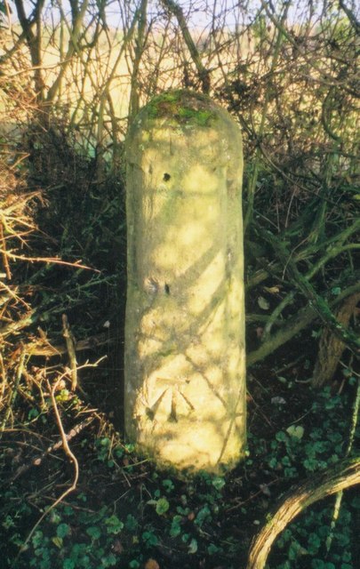
Stone post (plate lost) by the B4047 (was A40), in parish of MINSTER LOVELL (WEST OXFORDSHIRE District), Burford Road; at western edge of houses in Curbridge Downs; just outside 30mph zone, down a deep bank under bushes; where old path of road diverges from present road, on North side of road. Witney pillar and iron plate, erected by the Barrington & Campsfield turnpike trust in the 19th century.
Inscription once read:-
(Burford)
(5)
(Whitney)
(2)
Carved benchmark on bottom front face.
Oxfordshire HER listed.
HER Number: 10023 Link
Milestone Society National ID: OX_LGOx71.
Inscription once read:-
(Burford)
(5)
(Whitney)
(2)
Carved benchmark on bottom front face.
Oxfordshire HER listed.
HER Number: 10023 Link
Milestone Society National ID: OX_LGOx71.
National Survey of Wayside Features by The Milestone Society
These images are from Link
 Map © Crown Copyright")
TIP: Click the map for more Large scale mapping
- Grid Square
- SP3210, 13 images (more nearby 🔍)
- Photographer
- A Rosevear (more nearby)
- Contributed by
- Milestone Society (more nearby)
- Date Taken
- Tuesday, 3 December, 2002 (more nearby)
- Submitted
- Tuesday, 5 February, 2019
- Subject Location
-
OSGB36:
 SP 32688 10756 [1m precision]
WGS84: 51:47.6703N 1:31.6459W - Camera Location
-
OSGB36: SP 32688 10756
- View Direction
- North-northeast (about 22 degrees)