O1634 : Butt Bridge and Loopline Bridge
taken 6 years ago, near to Dublin, Ireland
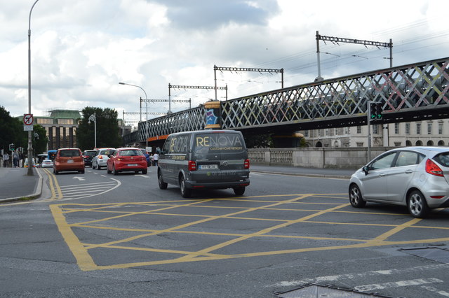
The Butt Bridgeis a road bridge in Dublin, which spans the River Liffey and joins Georges Quay to Beresford Place and the north quays at Liberty Hall.
The original bridge on this site was a structural steel swivel bridge, which was opened in 1879 and named for Isaac Butt (who died that year), leader of the Home Rule movement.
The swing section, made of wrought iron and weighing 200 tons, ran on a series of cast spoke wheels and was powered by a steam engine, which was housed on a timber pier on the downstream side of the bridge. The swing action allowed boats to pass and berth in the river as far upstream as Carlisle Bridge (now O'Connell Bridge).
In 1932, the swing bridge was replaced with a three span fixed structure of reinforced concrete, but retained its original English name.
The central span of the current bridge is formed by two cantilevered sections, with the two approach spans acting as counterweights. This model represented the first use in reinforced concrete of a cantilevered and counterweight construction in either Britain or Ireland.
The Loopline Bridge (or the Liffey Viaduct) is a railway bridge spanning the River Liffey and several streets in Dublin, Ireland. It joins rail services from south of Dublin to Connolly Station and lines north.
Designed by John Chaloner Smith (engineer to the Dublin, Wicklow and Wexford Railway), the bridge was built between 1889 and 1891. It consists of wrought iron lattice girders on a double row of piers with five spans. The viaduct is approximately six metres above street level and supports two railway tracks.
A box junction is a traffic control measure designed to prevent gridlock at busy road junctions. The surface of the junction is marked with a criss-cross grid of diagonal painted lines and vehicles may not enter the area so marked unless their exit from the junction is clear; drivers may enter the box and wait when they want to turn right and are stopped from doing so only by oncoming traffic or by other vehicles waiting to turn right. Link
![Creative Commons Licence [Some Rights Reserved]](https://s1.geograph.org.uk/img/somerights20.gif)
|
· Find out How to reuse this image ·
Share:
|
|||||
| Start a discussion on O1634 | Suggest an update to this image | Contact the contributor | |||
- Grid Square
- O1634, 761 images (more nearby
 )
)
- Photographer
- N Chadwick (find more nearby)
- Date Taken
- Friday, 3 August, 2018 (more nearby)
- Submitted
- Friday, 8 February, 2019
- Geographical Context
- Subject Location
-
Irish:
 O 162 344 [100m precision]
WGS84: 53:20.8532N 6:15.2996W - Camera Location
-
Irish: O 162 344
- View Direction
- North-northeast (about 22 degrees)