2019
TQ5699 : Radio mast above the Kelvedon Hatch Secret Nuclear Bunker
taken 5 years ago, near to Kelvedon Hatch, Essex, England
This is 1 of 2 images, with title Radio mast above the Kelvedon Hatch Secret Nuclear Bunker in this square
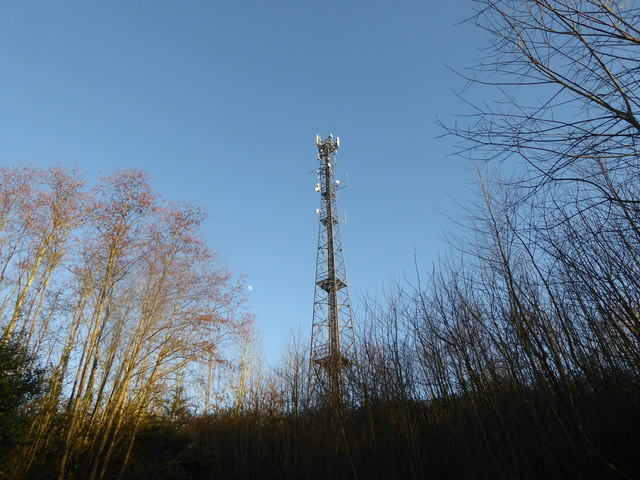
Radio mast above the Kelvedon Hatch Secret Nuclear Bunker
The Kelvedon Hatch Secret Nuclear Bunker was designed for up to 600 military and civilian personnel, including the Prime Minister, their collective task being to organise the survival of the population in the aftermath of a nuclear war. It was built into the side of a hill, was three storeys high, and you entered through a disguised bungalow at the lowest level and worked your way up. On top of the bunker was this 150 feet high radio mast.
The sights inside include a hospital ward with an operation taking place, another patient lying in bed and coffins against the wall! A Government information film shows a whole street on fire after a nuclear strike and people being encouraged to rush out with buckets of water to try and put the fires out. At least the commentator on the tour was more realistic - "after three months down here there would be nothing to come up for and there would just be roaming bands of zombies so you might as well take your cyanide pill" and "the aim of the government was to keep you occupied for a few weeks because by then you would be dead."
See Link and Link
The sights inside include a hospital ward with an operation taking place, another patient lying in bed and coffins against the wall! A Government information film shows a whole street on fire after a nuclear strike and people being encouraged to rush out with buckets of water to try and put the fires out. At least the commentator on the tour was more realistic - "after three months down here there would be nothing to come up for and there would just be roaming bands of zombies so you might as well take your cyanide pill" and "the aim of the government was to keep you occupied for a few weeks because by then you would be dead."
See Link
 Map © Crown Copyright")
TIP: Click the map for more Large scale mapping
- Grid Square
- TQ5699, 23 images (more nearby 🔍)
- Photographer
- Marathon (more nearby)
- Date Taken
- Friday, 15 February, 2019 (more nearby)
- Submitted
- Saturday, 23 February, 2019
- Subject Location
-
OSGB36:
 TQ 5613 9940 [10m precision]
WGS84: 51:40.3008N 0:15.3877E - Camera Location
-
OSGB36: TQ 5612 9939
- View Direction
- North-northeast (about 22 degrees)