J3474 : Former Ulster Sports Club, Belfast - February 2019(1)
taken 5 years ago, near to Belfast, Co Antrim, Northern Ireland
This is 1 of 2 images, with title starting with Former Ulster Sports Club, Belfast - February in this square
Former Ulster Sports Club, Belfast - February 2019(1)
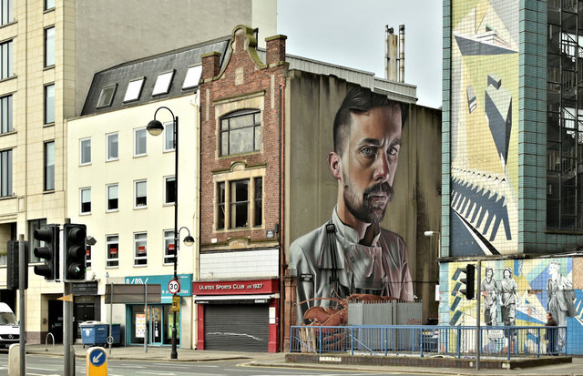
The former Ulster Sports Club, from Victoria Street. The building (left - the first extension to the Merchant Hotel) can be seen during an early stage of construction, in May 2009, J3474 : Hotel extension, Belfast. High Street Court (originally High Street Entry) J3474 : High Street Court, Belfast and this street art J3474 : Street art, High Street, Belfast (September 2016) are towards the right.
The 1939 street directory shows the club at 39 High Street, premises then home to numerous occupants
39. Ulster Sports Club
" Ward, William, agent
" Greenhill Bros. Ltd., coal and coke merchants
" Cowan, W., ticket writer
" Theosophical Society
" Lenfesty, P., Commission Agent. T.N.: 21741 and 23814
" Bell & Buchanan, agents
" Cordner, E. K., handkerchief manufacturer
" International Co-Freemasonry
" Little, A. & J., House and Land Agents.
Nos 96-98 High Street, Belfast
Built in 1935 as a furniture shop and later converted to the Ulster Sports Club, 96-98 Hight Street is now (February 2019) vacant. There is the following application (25 January 2019) for planning permission LA04/2019/0199/F Extension to the Merchant Hotel into adjacent building no 96-98 High Street (Ulster Sports Club)- change of use from registered social club to hotel. 96-98 High Street Belfast. If approved this would be the Merchant Hotels second expansion into adjoining property J3474 : Demolition site, Belfast.
I have no connection with the hotel or the application and cannot enter into correspondence.
![Creative Commons Licence [Some Rights Reserved]](https://s1.geograph.org.uk/img/somerights20.gif)
|
· Find out How to reuse this image ·
Share:
|
|||||
|
There are 4 posts in a
discussion on J3474 (preview on the left) |
Suggest an update to this image | Contact the contributor | |||
Loading map... (JavaScript required)
- Grid Square
- J3474, 4349 images (more nearby
 )
)
- Photographer
- Albert Bridge (find more nearby)
- Date Taken
- Saturday, 23 February, 2019 (more nearby)
- Submitted
- Sunday, 24 February, 2019
- Geographical Context
- Primary Subject of Photo
- Place (from Tags)
- Subject Location
-
Irish:
 J 341 744 [100m precision]
WGS84: 54:36.0392N 5:55.5157W - Camera Location
-
Irish: J 341 744
- View Direction
- WEST (about 270 degrees)
Other Tags
This page has been viewed about 170 times.
View this location:
KML (Google Earth) ·
Google Maps ·
Bing Maps ·
Geograph Coverage Map ·
More Links for this image
·
Bing Maps ·
Geograph Coverage Map ·
More Links for this image