2019
SX9587 : RAF Exminster: WW2 GCI radar station - Operations Block and Reporting Hall (1)
taken 5 years ago, near to Exminster, Devon, England
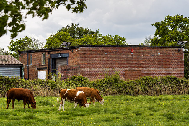
RAF Exminster: WW2 GCI radar station - Operations Block and Reporting Hall (1)
-
GCI Radar Station: EDoB ID: e25284
The photo is of the former Operations Block or "Happidrome", now part of an industrial complex and much altered with a modern infill between it and the former Standby Set House (the latter not in photo). The operations building was the nerve centre of the site, whose purpose was the interception by radar of enemy aircraft by ground controlled guidance of our fighters, mainly from RAF Exeter. The building contained the windowless reporting hall where personnel (mainly WAAF) worked at large map tables plotting both enemy and friendly aircraft movements the status of which was also recorded on a vertical 'Tote' board. They would be watched keenly by the chief controller looking down from a gallery, assisted by other staff who passed plots to aircraft as necessary. Link
A brief history. A Royal Air Force mobile *GCI radar unit (*Ground Controlled Interception) was moved from its previous location at Avebury in Wiltshire to the marshes of Exminster in March 1941, my father an RAF SNCO radar technician was one of the accompanying personnel. The station quickly established itself with fighters under Exminster's control accounting for three enemy aircraft between March and May 1941. The mobile station comprising various equipment mounted vehicles, gradually evolved to become an Intermediate establishment by the end of October 1942, when an aerial system, an operations hut and a powerhouse was built. By March 1943 further changes were in the offing when plans were put in motion to convert the site to a Final or Fixed GCI station. A brick and concrete operations block known as a "Happidrome" and a standby set powerhouse were built, and in the fields adjoining the main site various types of radars were established. Some of the buildings associated with these changes still exist - albeit in other guises, or in various states of dereliction.
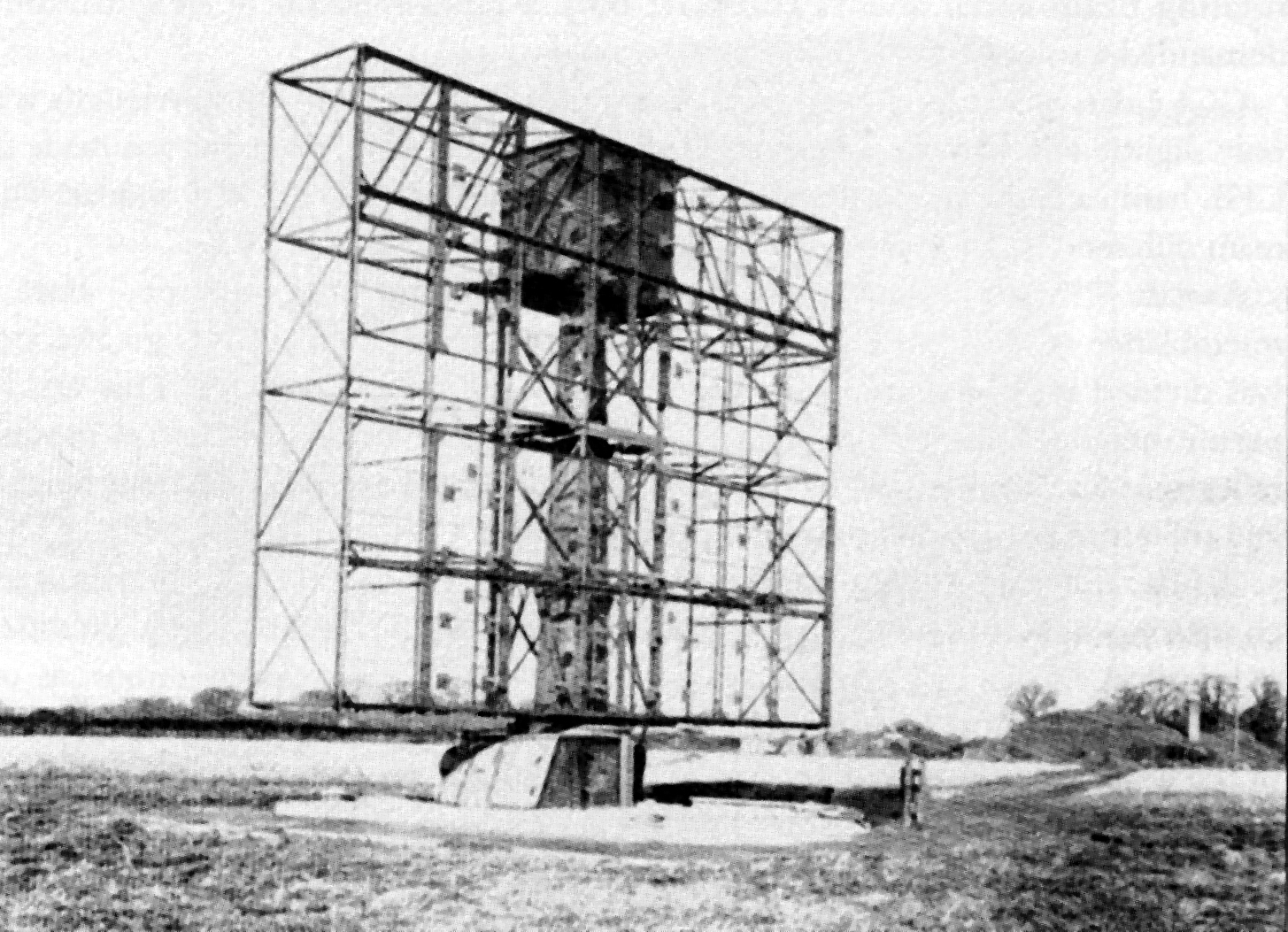
The most impressive structure of the Final phase, was the *AMES type 7 radar (*Air Ministry Experimental Station), whose large rotating aerial was the station's main radar, equipment that was to continue in operation in the RAF throughout the war and beyond, well into the 1960s Link. The aerial array sat above an underground bunker housing the transmitting and receiving equipment. Little trace of it can be seen today other than a small hump in the ground in a field adjacent to the public FP north east of the Ops Block, where occasionally a "parch mark" is also revealed during favourable weather conditions. In February 1945 RAF Exminster was placed on a care and maintenance (C & M) basis, and became for all intents and purposes non-operational, a status maintained into the mid-1950s. By 1956 it was officially transferred from military to civil use, and today the site is home to a small industrial estate, and an RSPB reserve.
With acknowledgements for the descriptions throughout this series of photos to Andrew & Mike Passmore's "Radar on the Marshes" A Brief History and Archaeology of Royal Air Force Station Exminster.
SX9587 : RAF Exminster: WW2 GCI radar station - Sewage Filtration Plant (2)
GCI Radar Station: EDoB ID: e25284
The photo is of the former Operations Block or "Happidrome", now part of an industrial complex and much altered with a modern infill between it and the former Standby Set House (the latter not in photo). The operations building was the nerve centre of the site, whose purpose was the interception by radar of enemy aircraft by ground controlled guidance of our fighters, mainly from RAF Exeter. The building contained the windowless reporting hall where personnel (mainly WAAF) worked at large map tables plotting both enemy and friendly aircraft movements the status of which was also recorded on a vertical 'Tote' board. They would be watched keenly by the chief controller looking down from a gallery, assisted by other staff who passed plots to aircraft as necessary. Link
A brief history. A Royal Air Force mobile *GCI radar unit (*Ground Controlled Interception) was moved from its previous location at Avebury in Wiltshire to the marshes of Exminster in March 1941, my father an RAF SNCO radar technician was one of the accompanying personnel. The station quickly established itself with fighters under Exminster's control accounting for three enemy aircraft between March and May 1941. The mobile station comprising various equipment mounted vehicles, gradually evolved to become an Intermediate establishment by the end of October 1942, when an aerial system, an operations hut and a powerhouse was built. By March 1943 further changes were in the offing when plans were put in motion to convert the site to a Final or Fixed GCI station. A brick and concrete operations block known as a "Happidrome" and a standby set powerhouse were built, and in the fields adjoining the main site various types of radars were established. Some of the buildings associated with these changes still exist - albeit in other guises, or in various states of dereliction.
The most impressive structure of the Final phase, was the *AMES type 7 radar (*Air Ministry Experimental Station), whose large rotating aerial was the station's main radar, equipment that was to continue in operation in the RAF throughout the war and beyond, well into the 1960s Link
With acknowledgements for the descriptions throughout this series of photos to Andrew & Mike Passmore's "Radar on the Marshes" A Brief History and Archaeology of Royal Air Force Station Exminster.
SX9587 : RAF Exminster: WW2 GCI radar station - Sewage Filtration Plant (2)
 Map © Crown Copyright")
TIP: Click the map for more Large scale mapping
- Grid Square
- SX9587, 100 images (more nearby 🔍)
- Photographer
- Mike Searle (more nearby)
- Date Taken
- Thursday, 9 May, 2019 (more nearby)
- Submitted
- Friday, 17 May, 2019
- Subject Location
-
OSGB36:
 SX 957 874 [100m precision]
WGS84: 50:40.6240N 3:28.6431W - Camera Location
-
OSGB36: SX 957 875
- View Direction
- SOUTH (about 180 degrees)