2019
SK6756 : Farnsfield-Southwell Trail, Kirklington Vicinity
taken 5 years ago, near to Kirklington, Nottinghamshire, England
This is 1 of 4 images, with title Farnsfield-Southwell Trail, Kirklington Vicinity in this square
Farnsfield-Southwell Trail, Kirklington Vicinity
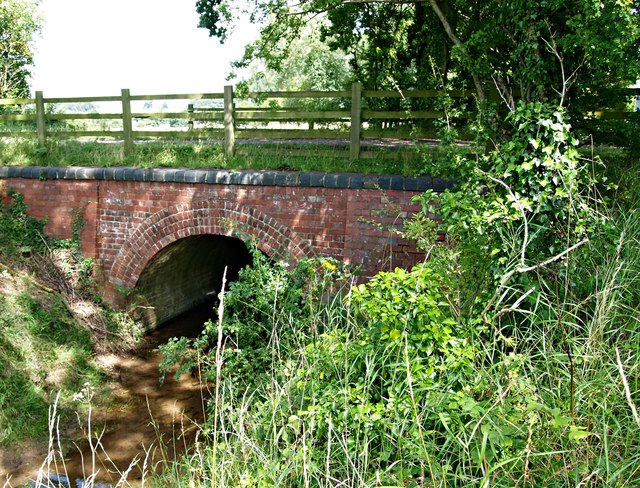
This former railway bridge over Edingley Beck is situated between the former Kirklington & Edingley Station (3-4 mins away on foot to the right of the picture) and the village of Farnsfield (15 mins walk away to the left). On the other side of the bridge - a mile or so further northwards - the beck empties into the River Greet. The Rolleston Junction to Southwell line - 2.5 miles in each direction - was a branch off the Midland Railway Companys Nottingham to Lincoln route. In 1871 the single line track was extended beyond Southwell to Mansfield to aid the transportation of coal in an easterly direction, bringing the total length of the line to 12.5 miles and doubling the amount of coal being exported. Passengers were also able to travel between stations on this Mansfield and Rolleston Junction branch service between 1929 - 59. Thereafter, the line continued to be used for coal trains and some excursion trains until 1965. The track was finally taken up in 1969 and the Southwell Trail was established. It now forms part of The Robin Hood Way long distance path.
 Map © Crown Copyright")
TIP: Click the map for more Large scale mapping
- Grid Square
- SK6756, 57 images (more nearby 🔍)
- Photographer
- David Hallam-Jones (more nearby)
- Date Taken
- Monday, 29 July, 2019 (more nearby)
- Submitted
- Tuesday, 30 July, 2019
- Subject Location
-
OSGB36:
 SK 674 565 [100m precision]
WGS84: 53:6.1354N 0:59.6595W - Camera Location
-
OSGB36: SK 674 565
- View Direction
- North-northwest (about 337 degrees)