J3576 : The "Oralora", Belfast harbour (August 2019)
taken 5 years ago, 3 km from Belfast, Co Antrim, Northern Ireland
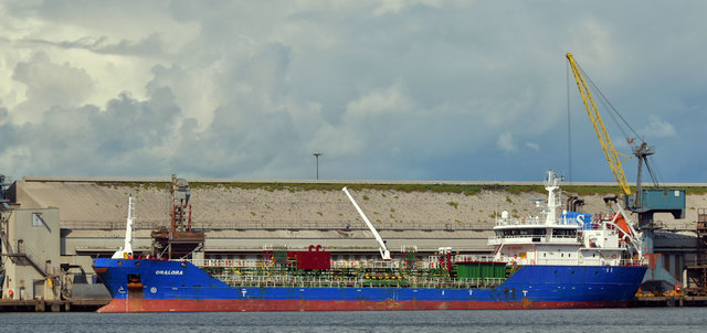
The "Oralora", Belfast harbour (August 2019)
The tanker Oralora (2011/90 metres/4,137 dwt) Link at the West Twin Wharf, discharging a part-cargo of molasses from Brest. Shifted, later the same day, to discharge the balance in the Barnett Dock.
West Twin Wharf, Belfast
Wharf at the Victoria Channel, Belfast docks.
The wharf was constructed in 1962-63 by Charles Brand & Son and has a total quayage of 212 metres. The large concrete silo, named West Twin Silo, was constructed 1962-64 for W.R Barnett and R. & H. Hall, with an extension added 1970-73. The modern metal silos to the far right are more recent additions again.
![Creative Commons Licence [Some Rights Reserved]](https://s1.geograph.org.uk/img/somerights20.gif)
|
· Find out How to reuse this image ·
Share:
|
|||||
| Start a discussion on J3576 | Suggest an update to this image | Contact the contributor | |||
Loading map... (JavaScript required)
- Grid Square
- J3576, 974 images (more nearby
 )
)
- Photographer
- Albert Bridge (find more nearby)
- Date Taken
- Saturday, 31 August, 2019 (more nearby)
- Submitted
- Saturday, 31 August, 2019
- Geographical Context
- Place (from Tags)
- Primary Subject of Photo
- Subject Location
-
Irish:
 J 357 767 [100m precision]
WGS84: 54:37.2306N 5:53.9500W - Camera Location
-
Irish: J 359 762
- View Direction
- North-northwest (about 337 degrees)
Other Tags
This page has been viewed about 71 times.
View this location:
KML (Google Earth) ·
Google Maps ·
Bing Maps ·
Geograph Coverage Map ·
More Links for this image