J5986 : The 'Yamal Spirit' off Orlock
taken 5 years ago, 6 km NE of Groomsport, Co Down, Northern Ireland
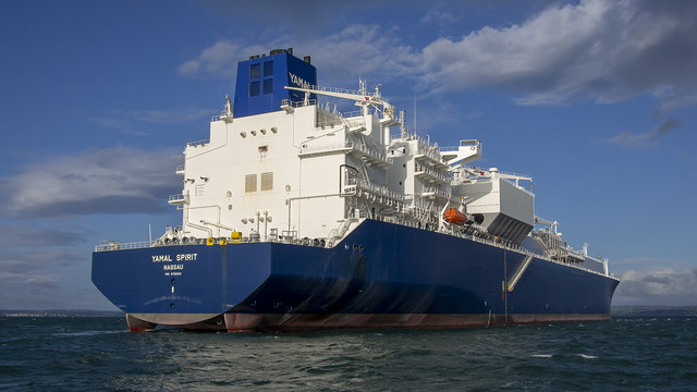
The 'Yamal Spirit' off Orlock
The 294m (91,610 DWT) Bahamian flagged LNG tanker 'Yamal Spirit' Link anchored off the Copeland Islands at the mouth of Belfast Lough.
The ship, launched in 2019, is a new class of vessel that can navigate in the freezing waters around the northern coast of Russia in all seasons. Working without an ice breaker, the ship can cope in up to 2.5 metres of ice through a reinforced hull and (I think) by going astern as a 'Double Acting Ship' Link .
Owned by Teekay Link the ship is on long-term charter to Yamal LNG Link and will be used to bring LNG from Russia to Asia and Europe.
The ship can hold up to 174,000 cubic metres of liquefied natural gas which is super-cooled to -162°C. The cooling process shrinks the volume of the gas 600 times, making it easier and safer to store and ship. In its liquid state, LNG will not ignite.
See also the 'Eduard Toll' J3675 : The 'Eduard Toll' at Belfast.
The ship, launched in 2019, is a new class of vessel that can navigate in the freezing waters around the northern coast of Russia in all seasons. Working without an ice breaker, the ship can cope in up to 2.5 metres of ice through a reinforced hull and (I think) by going astern as a 'Double Acting Ship' Link
Owned by Teekay Link
The ship can hold up to 174,000 cubic metres of liquefied natural gas which is super-cooled to -162°C. The cooling process shrinks the volume of the gas 600 times, making it easier and safer to store and ship. In its liquid state, LNG will not ignite.
See also the 'Eduard Toll' J3675 : The 'Eduard Toll' at Belfast.
![Creative Commons Licence [Some Rights Reserved]](https://s1.geograph.org.uk/img/somerights20.gif)
|
· Find out How to reuse this image ·
Share:
|
|||||
| Start a discussion on J5986 | Suggest an update to this image | Contact the contributor | |||
Loading map... (JavaScript required)
- Grid Square
- J5986, 11 images (more nearby
 )
)
- Photographer
- Rossographer (find more nearby)
- Date Taken
- Sunday, 1 September, 2019 (more nearby)
- Submitted
- Monday, 2 September, 2019
- Geographical Context
- Place (from Tags)
- Primary Subject of Photo
- Subject Location
-
Irish:
 J 590 869 [100m precision]
WGS84: 54:42.3486N 5:32.0304W - Camera Location
-
Irish: J 590 869
- View Direction
- Northwest (about 315 degrees)
Other Tags
This page has been viewed about 150 times.
View this location:
KML (Google Earth) ·
Google Maps ·
Bing Maps ·
Geograph Coverage Map ·
More Links for this image