2019
ST5872 : Crane 30 from M Shed, Bristol
taken 5 years ago, near to Bristol, England
This is 1 of 12 images, with title starting with Crane in this square
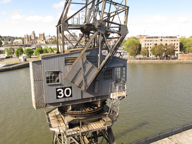
Crane 30 from M Shed, Bristol
This is on the Floating Harbour quay. On the left is the cathedral, beyond part of the Amphitheatre. On the right is Arnolfini contemporary art gallery. View from 2nd floor of M Shed.
River Avon (Bristol)
The River Avon is a river in the south west. To distinguish it from a number of other rivers of the same name, this river is often also known as the Bristol Avon. The name "Avon" is a derivation of the Welsh word afon, "river".
The Avon rises just north of the village of Acton Turville in South Gloucestershire, before flowing through Wiltshire. In its lower reaches from Bath to the Severn Estuary at Avonmouth near Bristol the river is navigable and known as the Avon Navigation. The river passes through both Bath and Bristol.
The Avon is the 19th longest river in the UK at 75 miles although there are just 19 miles as the crow flies between the source and its mouth in the Severn Estuary. The catchment area is 2,220 square kilometres.
 Map © Crown Copyright")
TIP: Click the map for more Large scale mapping
- Grid Square
- ST5872, 3780 images (more nearby 🔍)
- Photographer
- David Hawgood (more nearby)
- Date Taken
- Thursday, 12 September, 2019 (more nearby)
- Submitted
- Tuesday, 17 September, 2019
- Subject Location
-
OSGB36:
 ST 5852 7226 [10m precision]
WGS84: 51:26.8679N 2:35.8967W - Camera Location
-
OSGB36: ST 5852 7225
- View Direction
- NORTH (about 0 degrees)