J3675 : Cyclists, Sydenham bypass, Belfast (September 2019)
taken 5 years ago, 3 km from Belfast, Co Antrim, Northern Ireland
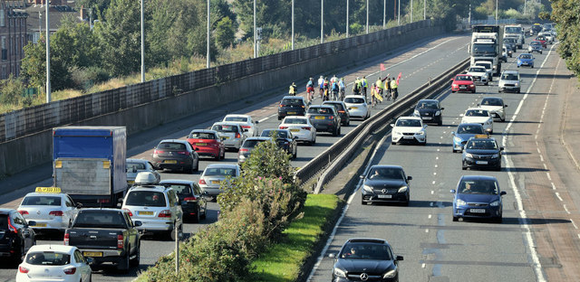
Cyclists, Sydenham bypass, Belfast (September 2019)
A group of cyclists heading inwards along the Sydenham bypass. Possibly the local contribution to the worldwide protest against global warming. This photograph appears as a matter of neutral visual record only.
The Sydenham bypass, Belfast
Approximately 2½ miles of dual carriageway forming part of the Belfast Bangor Road. It runs from the end of the M3 to Tillysburn, parallel to the Belfast Bangor railway and also serves the George Best Belfast City Airport. It replaced the Holywood Road as the main road to Holywood and Bangor. There are plans for major improvements at the junction with Dee Street.
![Creative Commons Licence [Some Rights Reserved]](https://s1.geograph.org.uk/img/somerights20.gif)
|
· Find out How to reuse this image ·
Share:
|
|||||
| Start a discussion on J3675 | Suggest an update to this image | Contact the contributor | |||
Loading map... (JavaScript required)
- Grid Square
- J3675, 583 images (more nearby
 )
)
- Photographer
- Albert Bridge (find more nearby)
- Date Taken
- Friday, 20 September, 2019 (more nearby)
- Submitted
- Sunday, 22 September, 2019
- Geographical Context
- Place (from Tags)
- Subject Location
-
Irish:
 J 369 753 [100m precision]
WGS84: 54:36.4780N 5:52.8372W - Camera Location
-
Irish: J 371 755
- View Direction
- Southwest (about 225 degrees)
Other Tags
Image Type (about):
cross grid
This page has been viewed about 133 times.
View this location:
KML (Google Earth) ·
Google Maps ·
Bing Maps ·
Geograph Coverage Map ·
More Links for this image
·
Bing Maps ·
Geograph Coverage Map ·
More Links for this image