2019
SK9508 : The North Brook
taken 4 years ago, near to Empingham, Rutland, England
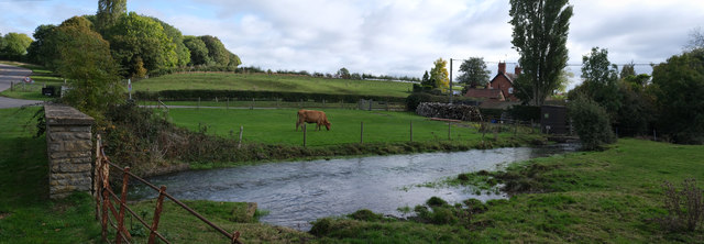
The North Brook
This tributary to the River Gwash is rather full, following the recent heavy rainfall.
 Map © Crown Copyright")
TIP: Click the map for more Large scale mapping
- Grid Square
- SK9508, 236 images (more nearby 🔍)
- Photographer
- Bob Harvey (more nearby)
- Date Taken
- Sunday, 20 October, 2019 (more nearby)
- Submitted
- Sunday, 20 October, 2019
- Subject Location
-
OSGB36:
 SK 9570 0888 [10m precision]
WGS84: 52:40.1515N 0:35.1734W - Camera Location
-
OSGB36: SK 9568 0889
- View Direction
- East-southeast (about 112 degrees)