2019
SN8397 : Bacheiddon Mine open cut
taken 5 years ago, 3 km from Aberhosan, Powys, Wales
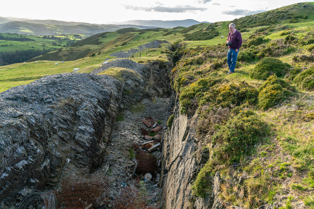
Bacheiddon Mine open cut
A very rich lead lode was discovered by a working miner in about 1851, close to the turnpike road to Dylife. This became the focus of considerable interest with the lode running to 8 tons of lead ore per cubic fathom. Deep mining was instigated by driving adits from both sides of the ridge, including a deep adit from the Rhoswydol Valley to the north east. Dividends of £1500 were paid out to shareholders in 1857-8 but this was not to last very long and by 1863 the mine had closed.The open cut is still an impressive feature close to the road, although, as with many such historical sites, this has become the dumping ground for agricultural rubbish and old car bodies.
 Map © Crown Copyright")
TIP: Click the map for more Large scale mapping
- Grid Square
- SN8397, 14 images (more nearby 🔍)
- Photographer
- Richard Bird (more nearby)
- Date Taken
- Saturday, 7 September, 2019 (more nearby)
- Submitted
- Saturday, 26 October, 2019
- Subject Location
-
OSGB36:
 SN 836 970 [100m precision]
WGS84: 52:33.5340N 3:43.0543W - Camera Location
-
OSGB36: SN 836 970
- View Direction
- WEST (about 270 degrees)