2019
TG2308 : Dragon Hall, King Street, Norwich
taken 4 years ago, near to Norwich, Norfolk, England
This is 1 of 5 images, with title Dragon Hall, King Street, Norwich in this square
Dragon Hall, King Street, Norwich
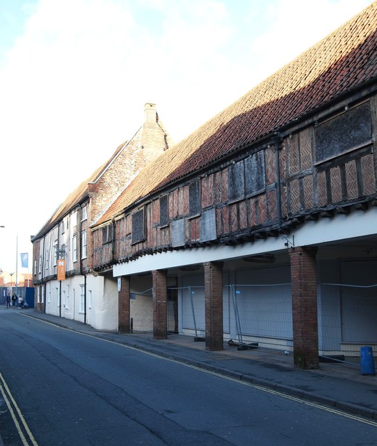
In the distance is the Dragon Hall. It was originally known as Splytts and was built c.1430 by Robert Toppes, a wealthy merchant (born c.1400) who owned approximately 31 properties in Norwich and beyond. Toppes was the citys mayor four times and is credited with helping Norwich to become the second largest and richest city in England. Because of its proximity to a nearby river and passable streets the premises were developed as a trading complex. Toppes set aside the first floor as a trading hall and maintained the ground floor as a reception area. There was also a warehouse next to the River Wensum. After his death, the building was repurposed for residential use. Over the years some of the original architecture was ripped away to make more space for even more tenants. An attic and cellar were added and the site was renamed The Old Barge Building. Part of the hall even became a pub. In the 1950s however, the building was awarded Grade I-listed status and in 1979 the City Council bought the property and with the help of a £1.8 million Heritage Lottery grant set out to restore it. It was renamed Dragon Hall after a carved and painted dragon in one of its roof spandrels. It is currently owned by the National Centre for Creative Writing.
 Map © Crown Copyright")
TIP: Click the map for more Large scale mapping
- Grid Square
- TG2308, 6226 images (more nearby 🔍)
- Photographer
- David Hallam-Jones (more nearby)
- Date Taken
- Monday, 23 December, 2019 (more nearby)
- Submitted
- Tuesday, 31 December, 2019
- Subject Location
-
OSGB36:
 TG 2355 0815 [10m precision]
WGS84: 52:37.5031N 1:18.0893E - Camera Location
-
OSGB36: TG 2356 0814
- View Direction
- North-northwest (about 337 degrees)