2019
TG2308 : Sandling's (Pull's) Ferry, Norwich
taken 4 years ago, near to Norwich, Norfolk, England
This is 1 of 3 images, with title Sandling's (Pull's) Ferry, Norwich in this square
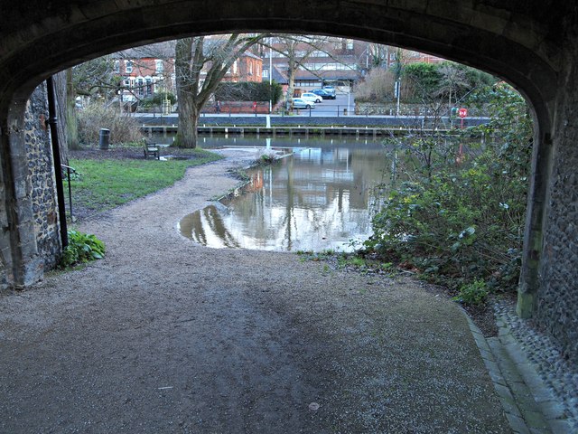
Sandling's (Pull's) Ferry, Norwich
A ferry, originally known as Sandlings Ferry, operated here - across the River Wensum - from the Early C17th until 1943. Sandling, it seems, was a local chorister who lived until the age of 89 years. Apparently it derives its current name from a ferryman called John Pull (or Poole), who worked the river crossing from a nearby inn between 1796 -1841. Following an attempt to close the ferry down, by extending the railway along the river edge (a scheme defeated by the cathedrals Dean Goulburn), the ferry operated until 1943. This Grade II-listed watergate originally served as the entrance from the river into a canal that ran towards the cathedral; the canal being originally used for transporting the Caen stone used in the construction of the cathedral. The waterway was built by Herbert de Losinga in order to allow work on the cathedral to begin in 1096. It was however, eventually filled in. The buildings are the property of the Dean and Chapter of Norwich Cathedral and they were restored in 1947. The handrail on the left is associated with a set of stone steps that lead up to a series of rooms above the arch. These are currently used by local Girl Guides. The A147 (a.k.a. Riverside Road) is visible opposite.
 Map © Crown Copyright")
TIP: Click the map for more Large scale mapping
- Grid Square
- TG2308, 6226 images (more nearby 🔍)
- Photographer
- David Hallam-Jones (more nearby)
- Date Taken
- Monday, 23 December, 2019 (more nearby)
- Submitted
- Wednesday, 1 January, 2020
- Subject Location
-
OSGB36:
 TG 2389 0875 [10m precision]
WGS84: 52:37.8178N 1:18.4146E - Camera Location
-
OSGB36: TG 2389 0875
- View Direction
- EAST (about 90 degrees)