2012
SD9420 : Old Milestone on Reddyshore Scout Gate - Burnley face
taken 12 years ago, near to Warland, Calderdale, England
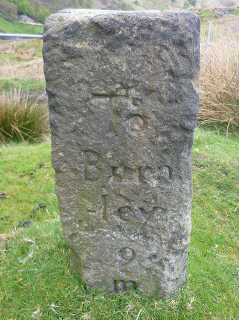
Old Milestone on Reddyshore Scout Gate - Burnley face
By the track, in parish of Todmorden (Calderdale District), Reddyshore Scout Gate, W of A6033, side of main paved track, nr narrow track leading down to Dean Royd.
Inscription reads clockwise:- : To / Burn / -ley / 9 / M : : To / Hali- / fax / 10 / M : : To / Roch- / dale / 5 / M : : To / Tod / Mor / den / 2 / M :
Surveyed
Milestone Society National ID: YW_XTODc
Inscription reads clockwise:- : To / Burn / -ley / 9 / M : : To / Hali- / fax / 10 / M : : To / Roch- / dale / 5 / M : : To / Tod / Mor / den / 2 / M :
Surveyed
Milestone Society National ID: YW_XTODc
National Survey of Wayside Features by The Milestone Society
These images are from Link
Guidestone at Reddyshore Scout Gate, Walsden
This stone has four inscribed faces as follows:
To Halifax 10 M
To Todmorden 2 M
To Burnley 9 M
To Rochdale 5 M
The routes would probably be packhorse tracks rather than roads, and the Halifax route would cross over the valley and climb over the hill via Salter Rake Gate and past Mankinholes to London Road. The Todmorden route might have been the same down to the valley, then would go left and go up and down on the valley side a few times. Reddyshore Scout Gate goes towards Rochdale, and the route would probably continue along Calderbrook Road. Burnley is a puzzle, as the 1850 six-inch map does not show a direct route over the moors.
There are no arrows to indicate directions.
 Map © Crown Copyright")
TIP: Click the map for more Large scale mapping
- Grid Square
- SD9420, 147 images (more nearby 🔍)
- Photographer
- Bob Muncaster (more nearby)
- Contributed by
- Milestone Society (more nearby)
- Date Taken
- Friday, 11 May, 2012 (more nearby)
- Submitted
- Friday, 17 January, 2020
- Subject Location
-
OSGB36:
 SD 9409 2026 [10m precision]
WGS84: 53:40.7262N 2:5.4568W - Camera Location
-
OSGB36: SD 9409 2026
- View Direction
- East-southeast (about 112 degrees)