SX2553 : Looe
taken 9 years ago, near to Looe, Cornwall, England
The River Looe is a river in south-east Cornwall, which flows into the English Channel at Looe. It has two main branches, the East Looe River and the West Looe River. The eastern branch has its source near St Cleer only 0.31 miles away from the Golitha Falls on the River Fowey, and flows south, passing close to the western outskirts of Liskeard. The western branch has its source near Dobwalls.
South of Liskeard, the Looe Valley Line railway follows the course of the East Looe River to Looe. The railway is so close to the river that flooding is a common occurrence.
The lowest stretch of the rivers combine to form the tidal harbour and estuary of Looe. The combined length of the two rivers (including the tidal confluence) is 30 miles
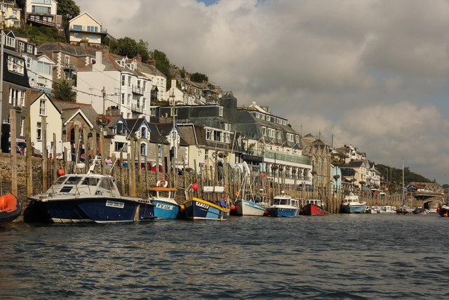
Looe, meaning deep water inlet is a small coastal town, fishing port in south-east Cornwall.
Looe is 20 miles west of Plymouth and 7 miles south of Liskeard, divided in two by the River Looe, East Looe and West Looe (meaning Little Cove) being connected by a bridge. Looe developed as two separate towns..
The town centres around a small harbour and along the steep-sided valley of the River Looe which flows between East and West Looe to the sea beside a sandy beach. Offshore to the west, opposite the stonier Hannafore Beach, lies Looe Island.
 Map © Crown Copyright")
- Grid Square
- SX2553, 702 images (more nearby 🔍)
- Photographer
- Richard Croft (more nearby)
- Date Taken
- Tuesday, 8 September, 2015 (more nearby)
- Submitted
- Sunday, 3 May, 2020
- Subject Location
-
OSGB36:
 SX 2538 5336 [10m precision]
WGS84: 50:21.2513N 4:27.3627W - Camera Location
-
OSGB36: SX 2541 5333
- View Direction
- Northwest (about 315 degrees)