2020
SE2988 : Damaged Benchmark on the wall of Clapham Lodge
taken 4 years ago, near to Leeming, North Yorkshire, England
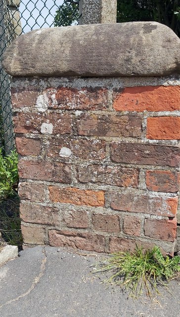
Damaged Benchmark on the wall of Clapham Lodge
Ordnance Survey cut mark benchmark on the lowest brick course, with the datum line evident, but the arrows are obscured by the tarmac on the pavement.
It was recorded on the 1890 OS Map at 120.1ft ASL.
It was recorded on the 1890 OS Map at 120.1ft ASL.
 Map © Crown Copyright")
TIP: Click the map for more Large scale mapping
- Grid Square
- SE2988, 22 images (more nearby 🔍)
- Photographer
- Matthew Hatton (more nearby)
- Date Taken
- Sunday, 14 June, 2020 (more nearby)
- Submitted
- Wednesday, 24 June, 2020
- Subject Location
-
OSGB36:
 SE 2982 8855 [10m precision]
WGS84: 54:17.5025N 1:32.6029W - Camera Location
-
OSGB36: SE 2981 8855
- View Direction
- East-northeast (about 67 degrees)