2020
TQ3403 : Locked basin - Brighton Marina
taken 4 years ago, near to Ovingdean, Brighton And Hove, England
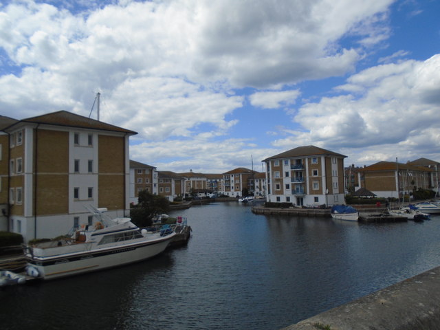
Locked basin - Brighton Marina
The marina covers an area of 127 acres stretching 1100 yards along the cliff face and approximately 600 yards out into the sea and when constructed was one of the largest artificial marinas in Britain. The original plan for construction was approved in November 1963 and envisaged the structure filled with yacht berths, hovercraft stations, flats, hotels and restaurants, conference facilities, casinos, bowling alleys, theatre and cinema. The proposed site was to the immediate south of Kemp Town adjacent to Dukes Mound. After much opposition it was moved eastwards to Black Rock and another plan submitted in 1965 which was approved as long as no building projected above the cliffs. After a public inquiry the government gave approval in 1966 and Parliament assented in 1968. Building was delayed further by the opposition who slowed the progress of a separate Bill required for the construction of a road access scheme that would see the removal of the small community based in Rifle Butt Road. This was eventually passed in 1970.
Site construction began in early 1971 with the inner harbour completed by 1975 and the outer breakwaters the following May 1976. However, there were still battles over what was to be included within which resulted in another inquiry 1974 that was approved the following year with proviso that no building was to exceed the height of the cliffs. In 1977 the lock gates connecting the inner and outer harbours were officially opened and the public gained admittance for the first time in the summer of 1978. The official opening ceremony was performed by the Queen the following year.
For the first half of the 1980s the Marina was solely for boats with very few buildings in evidence due to a lack of finance, see Link , for a view taken in 1985. A ferry terminal was opened in 1979 that offered a jetfoil service to Dieppe but was withdrawn the following year after a variety of problems including the size of the waves out in the channel. Changes commenced with its purchase by Brent Walker in 1985. The western end of the inner harbour was filled in and given over to the development of a supermarket which opened initially as a Gateway in 1987 becoming ASDA three years later. To its east the Octagon and the first buildings of the Marina Village were completed. In 1988 the cinema and multi-storey car park was opened. In 1989 the West Quay public house was opened on the site of the former RNLI station which moved southwards to the end of the quay.
In 1991 Brent Walker suffered financial difficulties due to debt fuelled acquisitions and a collapse of property prices resulting in a sale of the company's assets to recover money owed. As result building stopped and would not recommence until the Marina was acquired by current owners Brunswick Properties in 1996. As a consequence the housing and flats lining the inner harbour south of The Strand were built along with those to the east on the northern side. These had been completed by the turn of the century along with a casino, health centre and McDonald's to the south of the car park. In 2002 the commercial area around the Waterfront was completed.
In 2006 Brunswick announced more development including new flats and plans to redevelop ASDA, its filling station and McDonald's. The plans were shelved during the credit crunch but relaunched around 2010 and immediately faced opposition when it was discovered it included a forty storey skyscraper. Whilst original Act forbade the building above the cliff top the developers were able to use a local loophole to gain permission from the council. What was more surprising to many was the administration who approved it was run by the Green Party. Work commenced in 2014 on a new block on the West Quay that once more required the resiting of the RNLI station. Further blocks are to be built on reclaimed land near the entrance of the outer harbour and it is here where the skyscraper will be located.
Bibliography
Tim Carder - Encyclopedia of Brighton (1990)
Brighton Marina Website Link
My Brighton & Hove - Brighton Marina Link
Brighton & Hove Council Planning Applications Link
Evening Argus Website - Various articles Link
See other images of Brighton Marina
Site construction began in early 1971 with the inner harbour completed by 1975 and the outer breakwaters the following May 1976. However, there were still battles over what was to be included within which resulted in another inquiry 1974 that was approved the following year with proviso that no building was to exceed the height of the cliffs. In 1977 the lock gates connecting the inner and outer harbours were officially opened and the public gained admittance for the first time in the summer of 1978. The official opening ceremony was performed by the Queen the following year.
For the first half of the 1980s the Marina was solely for boats with very few buildings in evidence due to a lack of finance, see Link
In 1991 Brent Walker suffered financial difficulties due to debt fuelled acquisitions and a collapse of property prices resulting in a sale of the company's assets to recover money owed. As result building stopped and would not recommence until the Marina was acquired by current owners Brunswick Properties in 1996. As a consequence the housing and flats lining the inner harbour south of The Strand were built along with those to the east on the northern side. These had been completed by the turn of the century along with a casino, health centre and McDonald's to the south of the car park. In 2002 the commercial area around the Waterfront was completed.
In 2006 Brunswick announced more development including new flats and plans to redevelop ASDA, its filling station and McDonald's. The plans were shelved during the credit crunch but relaunched around 2010 and immediately faced opposition when it was discovered it included a forty storey skyscraper. Whilst original Act forbade the building above the cliff top the developers were able to use a local loophole to gain permission from the council. What was more surprising to many was the administration who approved it was run by the Green Party. Work commenced in 2014 on a new block on the West Quay that once more required the resiting of the RNLI station. Further blocks are to be built on reclaimed land near the entrance of the outer harbour and it is here where the skyscraper will be located.
Bibliography
Tim Carder - Encyclopedia of Brighton (1990)
Brighton Marina Website Link
My Brighton & Hove - Brighton Marina Link
Brighton & Hove Council Planning Applications Link
Evening Argus Website - Various articles Link
See other images of Brighton Marina
 Map © Crown Copyright")
TIP: Click the map for more Large scale mapping
- Grid Square
- TQ3403, 177 images (more nearby 🔍)
- Photographer
- Paul Gillett (more nearby)
- Date Taken
- Friday, 10 July, 2020 (more nearby)
- Submitted
- Friday, 10 July, 2020
- Subject Location
-
OSGB36:
 TQ 34078 03187 [1m precision]
WGS84: 50:48.7634N 0:5.8940W - Camera Location
-
OSGB36: TQ 34079 03216
- View Direction
- SOUTH (about 180 degrees)