2020
TQ2550 : The Old Town Hall
taken 4 years ago, near to Reigate, Surrey, England
This is 1 of 15 images, with title The Old Town Hall in this square
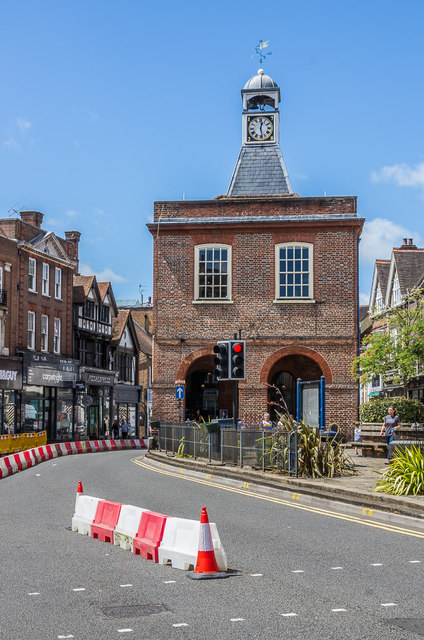
The Old Town Hall
The Old Town Hall from the Bell Street/Church Street/High Street junction. The barriers are for a temporary cycle lane that had been installed by Surrey County Council a couple of days earlier, on 3 July 2020, with the aim of encouraging cycling in Reigate and widening the pavements for pedestrians. Unfortunately the idea, admirable though it might have seemed, failed to recognise the frequent traffic jams in Reigate which occur with two lanes through the one way system, so potentially worsened with just one, and also the impact on deliveries and general access to the town centre. It was therefore quickly realised that rather than make the area more attractive to shoppers, it would instead have the opposite effect of damaging businesses by keeping them away. As a result, instead of being a 3 month experiment as planned, it lasted less than 3 days, the barriers being removed on 6 July, the day after this photo was taken.
 Map © Crown Copyright")
TIP: Click the map for more Large scale mapping
- Grid Square
- TQ2550, 1183 images (more nearby 🔍)
- Photographer
- Ian Capper (more nearby)
- Date Taken
- Sunday, 5 July, 2020 (more nearby)
- Submitted
- Monday, 13 July, 2020
- Subject Location
-
OSGB36:
 TQ 253 502 [100m precision]
WGS84: 51:14.2611N 0:12.3684W - Camera Location
-
OSGB36: TQ 253 502
- View Direction
- WEST (about 270 degrees)