J4893 : The Blackhead Path
taken 4 years ago, near to Whitehead, Co Antrim, Northern Ireland
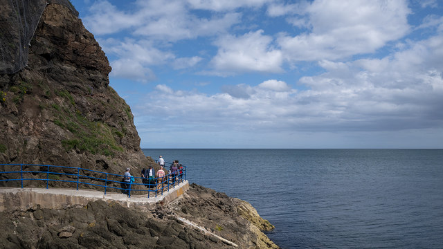
The Blackhead Path
The Blackhead Path, directly under the lighthouse. After being closed for many months it has reopened following an extensive restoration.
The Blackhead Path, Whitehead
A path running from The Banks at Whitehead, along the shore, to the Blackhead Lighthouse (with a parallel path running inland along the cliff and higher ground). It is possible to walk back to Whitehead from the lighthouse, on a surfaced path, via Muldersleigh Hill, McCreas Brae and the Islandmagee Road. Steep in places and not suitable for wheelchairs.
![Creative Commons Licence [Some Rights Reserved]](https://s1.geograph.org.uk/img/somerights20.gif)
|
· Find out How to reuse this image ·
Share:
|
|||||
| Start a discussion on J4893 | Suggest an update to this image | Contact the contributor | |||
Loading map... (JavaScript required)
- Grid Square
- J4893, 99 images (more nearby
 )
)
- Photographer
- Rossographer (find more nearby)
- Date Taken
- Sunday, 19 July, 2020 (more nearby)
- Submitted
- Monday, 27 July, 2020
- Geographical Context
- Place (from Tags)
- Primary Subject of Photo
- Subject Location
-
Irish:
 J 488 934 [100m precision]
WGS84: 54:45.9985N 5:41.3284W - Camera Location
-
Irish: J 487 934
- View Direction
- EAST (about 90 degrees)
Other Tags
This page has been viewed about 48 times.
View this location:
KML (Google Earth) ·
Google Maps ·
Bing Maps ·
Geograph Coverage Map ·
More Links for this image
·
Bing Maps ·
Geograph Coverage Map ·
More Links for this image