2009
SU8604 : Former Church of St Olave, North Street, Chichester
taken 15 years ago, near to Chichester, West Sussex, England
This is 1 of 2 images, with title Former Church of St Olave, North Street, Chichester in this square
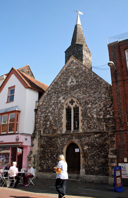
Former Church of St Olave, North Street, Chichester
The Grade I Listed church was founded in the 11th century and closed in 1955. Parishes in Chichester were, until 1845, peculiars of the Dean of Chichester and so were outside the jurisdiction of the Archbishop of Canterbury. It was perhaps built shortly before the Conquest, around 1050, possibly established by Earl Godwin. King Olaf or Olave of Norway was recognised as a saint in the year following his death in 1030. The new chancel was probably built 1220-30 at the time of the advowson from Ellis, son of Ralph de la Claye and the acquirement of the church by Master Simon the Dean, which occurred before 1260. The 13th-century chancel has been badly set out and leans to the north. Considerable alterations were carried out early in the 14th century. The chancel arch was rebuilt in 1851. In 1899 St. Martin's parish was united to St. Olave's. In 1956 it was a Society for Promoting Christian Knowledge bookshop. Under new management in 2008 it closed soon after, reopening in December 2009. In order to stay a consecrated building, a service of worship must be conducted annually. This happens on July 29, which is the Feast of St Olave and coincides with the date of his death.
 Map © Crown Copyright")
TIP: Click the map for more Large scale mapping
- Grid Square
- SU8604, 1117 images (more nearby 🔍)
- Photographer
- Jo and Steve Turner (more nearby)
- Date Taken
- Thursday, 24 September, 2009 (more nearby)
- Submitted
- Friday, 21 August, 2020
- Subject Location
-
OSGB36:
 SU 8609 0488 [10m precision]
WGS84: 50:50.2234N 0:46.7267W - Camera Location
-
OSGB36: SU 8607 0488
- View Direction
- East-northeast (about 67 degrees)