2020
SD7286 : Ford below Tommy Bridge
taken 4 years ago, near to Dent, Cumbria, England
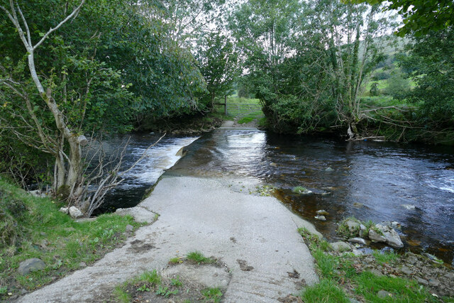
Ford below Tommy Bridge
Those like ourselves, on foot, wishing to cross the River Dee have the benefit of a footbridge a short way upstream of this, which the OS map shows as a bridleway. Good luck with that! The bridge does have a nice mounting block at the southern end, so if you happen to be possessed of a small enough pony, I imagine you are expected to carefully lead it across. Most would prefer to stay mounted and use this ford, which is substantially constructed and no doubt meant for farm machinery as much as equestrians. To those using the right of navigation on the river (who would only be here when the river was quite a bit higher) it's one of those man-made hazards we'd prefer didn't exist, as the sharp pour-over will no doubt create a retentive stopper in high water.
 Map © Crown Copyright")
TIP: Click the map for more Large scale mapping
- Grid Square
- SD7286, 119 images (more nearby 🔍)
- Photographer
- Andy Waddington (more nearby)
- Date Taken
- Friday, 25 September, 2020 (more nearby)
- Submitted
- Monday, 28 September, 2020
- Subject Location
-
OSGB36:
 SD 7253 8626 [10m precision]
WGS84: 54:16.2749N 2:25.3985W - Camera Location
-
OSGB36: SD 7254 8624
- View Direction
- North-northwest (about 337 degrees)