NJ3365 : Pillbox under Attack
taken 4 years ago, near to Kingston, Moray, Scotland
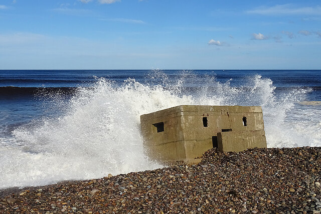
Update: three years later, the sea has removed some of the stones that have been partly protecting it NJ3365 : Pillbox at Risk.
The 'Sea of Stones' extends for several kilometres along the Moray Firth from Spey Bay towards Lossiemouth, and it is up to about 800 metres wide. It is the one of the largest shingle systems in Britain, and a classic demonstration of isostatic uplift.
It is an extensive series of shingle (or rather, pebble and cobble) ridges parallel to the coastline. These ridges provide evidence that the land is rising relative to the sea. During the last Ice Age, Scotland was under many hundreds of metres of ice, and the weight of the ice was enough to press the crust of the Earth here down into the mantle. Since the ice melted about 10,000 years ago, the land has continued to rise very slowly, about 1.5 millimetres a year. This process is termed isostatic uplift.
Each of these ridges is a storm beach piled up by the sea, and then fossilised as the sea retreated and could no longer reach and rearrange successive ridges. What used to be the foot of the cliff is now some 15 metres above sea level.
Not only that, but the Sea of Stones is a brilliant place to see a dynamic coastline in action. During the Second World War a line of tank traps and pill boxes was built to protect the low-lying coast from enemy invasion. Now, just 7 decades later, the changes in the shingle have buried and then uncovered again the eastern end of the defences as the sea has encroached on the land, while at the western end some of the defensive line is now well inland in the forest, and the shingle has piled up so high that many of the pill boxes no longer have a view of the sea at all.
Sadly, part of the ridges were obliterated to build rifle ranges as part of the defences. One range was still in use until a year or three ago, but I believe it has now been declared surplus to requirements so there is no need to worry about the mapped 'Danger Area'. Even when it was active, there were always sentries guarding the access points to prevent walkers getting into danger.
 Map © Crown Copyright")
- Grid Square
- NJ3365, 108 images (more nearby 🔍)
- Photographer
- Anne Burgess (more nearby)
- Date Taken
- Friday, 2 October, 2020 (more nearby)
- Submitted
- Friday, 9 October, 2020
- Subject Location
-
OSGB36:
 NJ 3316 6584 [10m precision]
WGS84: 57:40.6460N 3:7.3433W - Camera Location
-
OSGB36: NJ 3313 6583
- View Direction
- East-northeast (about 67 degrees)