2020
NT5985 : Tantallon Castle
taken 4 years ago, near to Auldhame, East Lothian, Scotland
This is 1 of 43 images, with title Tantallon Castle in this square
Tantallon Castle
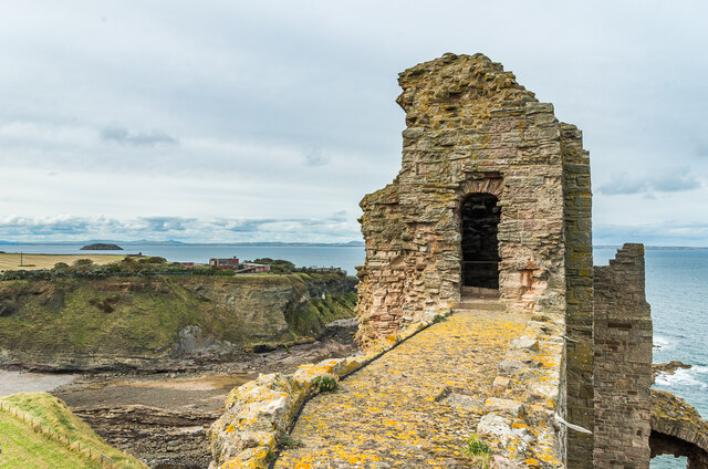
Looking along to the Douglas Tower of the main curtain wall of Tantallon Castle. In the background is Gin Head, with the former Gin Head Research Establishment on top of the cliff beyond. In the far distance on the left is the island of Craigleith with the Lomond Hills beyond.
Tantallon Castle
Castle built in the mid 14th Century by William Douglas, 1st Earl of Douglas, on a promontory, with cliffs on three sides forming a natural defence, with a single wall on the landward side. It is the last medieval curtain wall castle built in Scotland. It suffered damage in the 15th, 16th and 17th Centuries, with the latter caused by a siege by General Monck during Oliver Cromwell's invasion of Scotland in 1651. In 1699 the ruins were sold by James Douglas, 2nd Marquess of Douglas, to Sir Hew Dalrymple, and it was one of his descendants who passed it to the Office of Works in 1924. It is now in the care of Historic Environment Scotland and is designated as a scheduled monument - see Link
.
 Map © Crown Copyright")
TIP: Click the map for more Large scale mapping
- Grid Square
- NT5985, 157 images (more nearby 🔍)
- Photographer
- Ian Capper (more nearby)
- Date Taken
- Wednesday, 23 September, 2020 (more nearby)
- Submitted
- Sunday, 22 November, 2020
- Subject Location
-
OSGB36:
 NT 595 850 [100m precision]
WGS84: 56:3.4003N 2:39.0616W - Camera Location
-
OSGB36: NT 595 850
- View Direction
- West-northwest (about 292 degrees)