2020
NS3980 : North Street from the railway footbridge
taken 3 years ago, near to Alexandria, West Dunbartonshire, Scotland
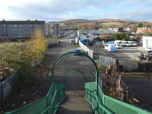
North Street from the railway footbridge
From the foot of the steps (NS3980 : Footbridge over the railway line), North Street continues ahead for about 320 metres before meeting Main Street. On the other side of Main Street, Hill Street continues on more or less the same line.
Overton Muir (NS371799) occupies the central part of the background, with Bromley Muir (NS369805) to its right (NNW).
Like Main Street, North Street was in existence when the first-edition OS map was surveyed in 1860. Hill Street, on the other side of Main Street, had not yet been built.
North Street was at that time appropriately named, being the northern limit of development in this part of Alexandria.
The railway footbridge from which this picture was taken was also present in 1860. The view from there would then have shown gasworks to the right (north) of the road, where there is now a garage. There is still a gas governor there.
The eastern side of the footbridge, the side behind the photographer, is shown in NS3980 : Footbridge over the railway line.
 Map © Crown Copyright")
TIP: Click the map for more Large scale mapping
- Grid Square
- NS3980, 138 images (more nearby 🔍)
- Photographer
- Lairich Rig (more nearby)
- Date Taken
- Thursday, 19 November, 2020 (more nearby)
- Submitted
- Tuesday, 29 December, 2020
- Subject Location
-
OSGB36:
 NS 3926 8041 [10m precision]
WGS84: 55:59.3788N 4:34.7058W - Camera Location
-
OSGB36: NS 3929 8042
- View Direction
- West-southwest (about 247 degrees)