TQ5739 : Victoria Grove
taken 3 years ago, near to Royal Tunbridge Wells, Kent, England
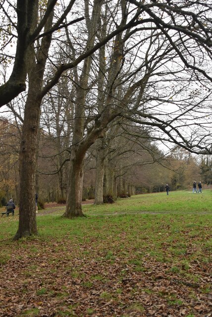
Planted in February 1835 as a double avenue to commemorate visits to the town by Princess Victoria with her mother the Duchess of Kent. Just to the north was the earlier Queens Grove, planted for the coronation of Queen Anne in 1702 and replanted in 1811; this never did well and died out in the early 1850s. Victoria Grove was planned as three rows of sycamores, limes, and elms, but some trees had to be replaced in later years and often did not conform to the original plan. The elms succumbed to disease in 1972, and in 1992 the third row was replanted to celebrate the fortieth anniversary of Elizabeth II's accession. For a few years from 1911 a moveable bandstand was set up to the south. To the north of the Grove is a small patch of surviving heathland, a type of vegetation once much more widespread on the Common. (TWCC)
Tunbridge Wells Common is a 104 hectare open space close to the centre of town. Comprising mixed oak woodland and open areas. Originally a common where animals grazed, but trees have grown as grazing declined. Underlain by Tunbridge Wells Sandstone (Lower Cretaceous), which outcrops in several places across the common. Owned by the Borough Council but looked after by the Tunbridge Wells Common Conservators Link
.
 Map © Crown Copyright")
- Grid Square
- TQ5739, 845 images (more nearby 🔍)
- Photographer
- N Chadwick (more nearby)
- Date Taken
- Saturday, 21 November, 2020 (more nearby)
- Submitted
- Saturday, 13 February, 2021
- Subject Location
-
OSGB36:
 TQ 5782 3900 [10m precision]
WGS84: 51:7.7124N 0:15.2423E - Camera Location
-
OSGB36: TQ 5785 3902
- View Direction
- West-southwest (about 247 degrees)