TQ5045 : The Chiding Stone
taken 4 years ago, near to Chiddingstone, Kent, England
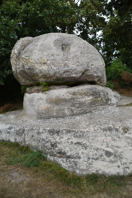
This tor like structure is 135 million year old Tunbridge Wells Sandstone.
It is a large sandstone, wind formed rock formation, situated on the edge of the village. It was probably used as a Saxon boundary marker as the village's name means the stone of Chidda's tribe' The name Chidda presumably being a local Saxon leader. Some have associated it with the Druids and others believe that the stone was used as a site of punishment mainly for local witches or wives, hence the name chide. It is an odd and atmospheric site and never appears to be overgrown.
Chiddingstone is a small village in West Kent. The village is unique, in that apart from the castle and church, it is entirely owned by the National trust. Many of the buildings in the village are listed buildings. Apart from the church the village as a shop and pub. On the edge of the village is a sandstone formation called the Chiding Stone TQ5045 : The Chiding Stone.
Website: Link
Tunbridge Wells sandstone is Lower Cretaceous in age. It was lain down in large braided river channels. Today it's outcrops form upland regions across the Weald of Kent. In the Tunbridge Wells area there are several locally famous sites. Mount Edgecumbe Rocks TQ5739 : Edgecumbe Rocks, Wellington Rocks TQ5739 : Wellington Rocks, Tunbridge Wells Common, Toad Rock TQ5639 : Toad Rock, Rusthall, Happy Valley Rocks TQ5639 : Happy Valley Rocks, High Rocks TQ5638 : High Rocks, Eridge Rocks TQ5535 : Eridge Rocks, The Chiddingstone TQ5045 : The Chiding stone, Chiddingstone, Harrison Rocks
The rock makes for good rock climbing in the SE of England.
The rock is locally rich in Iron and mining it gave the Wealden area an Iron making industry in Mediaevil times. It also accounts for a number of Chalybeate springs across Kent and Sussex.
 Map © Crown Copyright")
- Grid Square
- TQ5045, 562 images (more nearby 🔍)
- Photographer
- N Chadwick (more nearby)
- Date Taken
- Friday, 31 July, 2020 (more nearby)
- Submitted
- Saturday, 13 March, 2021
- Subject Location
-
OSGB36:
 TQ 5007 4508 [10m precision]
WGS84: 51:11.1153N 0:8.7540E - Camera Location
-
OSGB36: TQ 5008 4508
- View Direction
- Northwest (about 315 degrees)