2020
TM3337 : Bawdsey and the Deben Haven From Brackenbury, Felixstowe
taken 4 years ago, 3 km from Bawdsey, Suffolk, England
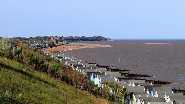
Bawdsey and the Deben Haven From Brackenbury, Felixstowe
Photo taken from near to the site of the WW1, WW2 coastal defence battery of Brackenbury Fort.
Link
View north east up the coast to:
2. Walton Castle
Link
A Roman era Saxon Shore Fort, built between AD 276-285 and stood circa 30 metres above sea level before being destroyed by sea erosion in the 18th century.
Link
Beyond the site of the castle are the shoals at the mouth of the Deben which shift continuously and ...
2. Martello Tower T
Link
The golf links in which the Martello Tower stands were the site of Operation Outward, a British World War II program to attack Germany by means of free-flying balloons. A total of 99,142 Outward balloons were launched; about half carried incendiaries and half carried trailing wires.
Link
2. Bawdsey Manor
Link
Immediately behind Tower T is Bawdsey Manor purchased by the Air Ministry in 1936 to establish a research station for developing the Chain Home RDF (radar) system. RAF Bawdsey was a base through the Cold War until the 1990s. A remaining radar mast can be seen on the skyline to the right of the manor house. There is radar museum in the manor grounds Link
3. Orfordness Lighthouse
Link
To the right of the headland at Bawdsey on the skyline the lighthouse is visible. It was demolished in July 2020, just after this picture was taken. To the left of the lighthouse are various of the buildings including the Atomic Weapons Research Establishment on the Ness. The Radar Tower is identifiable. Link
Until I got this picture home and could blow the picture up to full size I did not know that I had a photo of the lighthouse and I had not been aware that it even was possible to see it up the coast past Bawdsey. See John Sutton's earlier shot of the lighthouse from Felixstowe Link
Link
View north east up the coast to:
2. Walton Castle
Link
A Roman era Saxon Shore Fort, built between AD 276-285 and stood circa 30 metres above sea level before being destroyed by sea erosion in the 18th century.
Link
Beyond the site of the castle are the shoals at the mouth of the Deben which shift continuously and ...
2. Martello Tower T
Link
The golf links in which the Martello Tower stands were the site of Operation Outward, a British World War II program to attack Germany by means of free-flying balloons. A total of 99,142 Outward balloons were launched; about half carried incendiaries and half carried trailing wires.
Link
2. Bawdsey Manor
Link
Immediately behind Tower T is Bawdsey Manor purchased by the Air Ministry in 1936 to establish a research station for developing the Chain Home RDF (radar) system. RAF Bawdsey was a base through the Cold War until the 1990s. A remaining radar mast can be seen on the skyline to the right of the manor house. There is radar museum in the manor grounds Link
3. Orfordness Lighthouse
Link
To the right of the headland at Bawdsey on the skyline the lighthouse is visible. It was demolished in July 2020, just after this picture was taken. To the left of the lighthouse are various of the buildings including the Atomic Weapons Research Establishment on the Ness. The Radar Tower is identifiable. Link
Until I got this picture home and could blow the picture up to full size I did not know that I had a photo of the lighthouse and I had not been aware that it even was possible to see it up the coast past Bawdsey. See John Sutton's earlier shot of the lighthouse from Felixstowe Link
 Map © Crown Copyright")
TIP: Click the map for more Large scale mapping
- Grid Square
- TM3337, 122 images (more nearby 🔍)
- Photographer
- Tim Marchant (more nearby)
- Date Taken
- Sunday, 31 May, 2020 (more nearby)
- Submitted
- Sunday, 21 March, 2021
- Subject Location
-
OSGB36:
 TM 336 379 [100m precision]
WGS84: 51:59.4660N 1:24.0797E - Camera Location
-
OSGB36: TM 319 355
- View Direction
- Northeast (about 45 degrees)