2021
TL4459 : Notice at Histon Road Cemetery
taken 3 years ago, near to Chesterton, Cambridgeshire, England
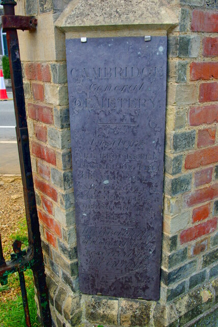
Notice at Histon Road Cemetery
CAMBRIDGE
General
CEMETERY
---
Visitors
ARE REQUESTED
TO KEEP ON THE
GRAVEL PATHS
AND NOT TO PLUCK
THE FLOWERS
OR INJURE THE
SHRUBS
---
No gratuity
allowed to be
received by
the Curator.
The Cambridge General Cemetery Company was founded in 1843 by a group of local nonconformist businessmen, to provide a burial site open to all. The noted garden designer John Claudius Loudon planned the layout and planting with trees and shrubs.
The company was wound up in 1936 and a chapel (designed by the rogue Gothic architect Edward Buckton Lamb) was demolished in 1957, but Lamb's original lodge in Histon Road Link remains in use as a private residence, punningly named Grave's End. Maintenance of the cemetery is now the responsibility of the City Council with the aid of a volunteer group of Friends.
Histon Road Cemetery Link is listed Grade II* Link
General
CEMETERY
---
Visitors
ARE REQUESTED
TO KEEP ON THE
GRAVEL PATHS
AND NOT TO PLUCK
THE FLOWERS
OR INJURE THE
SHRUBS
---
No gratuity
allowed to be
received by
the Curator.
The Cambridge General Cemetery Company was founded in 1843 by a group of local nonconformist businessmen, to provide a burial site open to all. The noted garden designer John Claudius Loudon planned the layout and planting with trees and shrubs.
The company was wound up in 1936 and a chapel (designed by the rogue Gothic architect Edward Buckton Lamb) was demolished in 1957, but Lamb's original lodge in Histon Road Link remains in use as a private residence, punningly named Grave's End. Maintenance of the cemetery is now the responsibility of the City Council with the aid of a volunteer group of Friends.
Histon Road Cemetery Link
Histon Road Cemetery
Histon Road Cemetery, formerly Cambridge General Cemetery, is a cemetery in north Cambridge, England, lying off Histon Road, opened in 1842. It is notable as one of only three designs by John Claudius Loudon, who covers it in detail in his influential book On the Laying Out, Planting and Managing of Cemeteries (1843).
Wikipedia: Link
 Map © Crown Copyright")
TIP: Click the map for more Large scale mapping
- Grid Square
- TL4459, 1456 images (more nearby 🔍)
- Photographer
- Tiger (more nearby)
- Date Taken
- Saturday, 27 March, 2021 (more nearby)
- Submitted
- Monday, 29 March, 2021
- Subject Location
-
OSGB36:
 TL 4432 5965 [10m precision]
WGS84: 52:12.9700N 0:6.6641E - Camera Location
-
OSGB36: TL 4432 5965
- View Direction
- WEST (about 270 degrees)