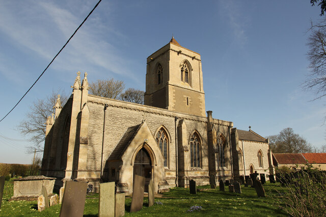
SK8043 : St Mary's church
taken 3 years ago, near to Staunton in The Vale, Nottinghamshire, England
That there has been a place of worship on this site is evidenced by an entry in the Domesday Book which records that there was a priest and a church and a mill
The mill, which was situated at the confluence of the Devon and Winterbeck streams, has long since gone but the church, dedicated to St Mary the Virgin still stands as a monument to a continuing Christian presence here in rural Nottinghamshire.
Until 1826, when it was demolished, there also stood within the present churchyard a much smaller chapel (Staunton Chapel) built around 1346. The precise location of this edifice is not known with any certainty but it is known to have been contemporary with the oldest parts of the present building on the site.
Access to the church is through the South Porch which leads directly into the Nave. This part of the building and the porch were rebuilt in 1853/54 by Mrs Isabella Staunton. From the style of restoration it is clear that care was take to reproduce the architecture of the pre-existing building: the stonework tracery of the windows in the south wall owe much to the styles of the 14th century.
To the north side of the Nave lies an area known as the St Lawrence Quire. This, separated from the nave by an arcade of three octagonal columns, along with the Tower represents the remains of the original 14th century building. Precisely what was the function of this part of the building is unclear: there is no indications of the presence of a chapel altar at its eastern end. From the evidence of the tombs it was, however, used from an early date as the final resting place of a number of the early Staunton ancestors. These are represented by tomb figures. Two Staunton 14th century knights in full armour and a lady, Dame Joan de Staunton, who died in 1366. There are other members of the family both in the raised tombs at the east end of the Quire and beneath memorial grave stones set in the floor. The Quire is lit by glazed windows, two in the north wall and a further one in the west wall. Each of them is in the style of the 14th century albeit possibly showing signs of some modification in the rebuilding of the mid 19th century.
A door in the north wall is contemporary with the 14th century architecture and on its outer side shows the typical ogee shape to its top surmounted by an empty niche normally used for a statue of a saint in this case perhaps St Lawrence.
At the western end of the Nave are two organs: the larger pipe organ is currently in use and is the successor to the smaller barrel organ of 1852.
The chancel is of typical Victorian style with the pair of windows in the south wall and the richly coloured stained glass window in the east end still reflecting the architectural style of the 14th century.
The tower is sited at the east end of the St Lawrence Quire and is a massively built 14th century structure some 21ft square at the top surmounted by a squat pyramidal spire that appears to be out of scale with the rest of the building. Indeed the internal architecture indicated that it was originally intended by its designer to have a much higher spire, perhaps tall enough to compete with that of the church in Bottesford. The bell chamber contains a peal of five bells the oldest dating from 1604.
Info take from church info by Revd Cannon J H Bateson, April 2000
 Map © Crown Copyright")
- Grid Square
- SK8043, 96 images (more nearby 🔍)
- Photographer
- Richard Croft (more nearby)
- Date Taken
- Tuesday, 30 March, 2021 (more nearby)
- Submitted
- Sunday, 4 April, 2021
- Subject Location
-
OSGB36:
 SK 8052 4327 [10m precision]
WGS84: 52:58.8442N 0:48.1307W - Camera Location
-
OSGB36: SK 8051 4324
- View Direction
- North-northeast (about 22 degrees)