2021
TG0632 : Briston village sign
taken 3 years ago, near to Briston, Norfolk, England
This is 1 of 2 images, with title Briston village sign in this square
Briston village sign
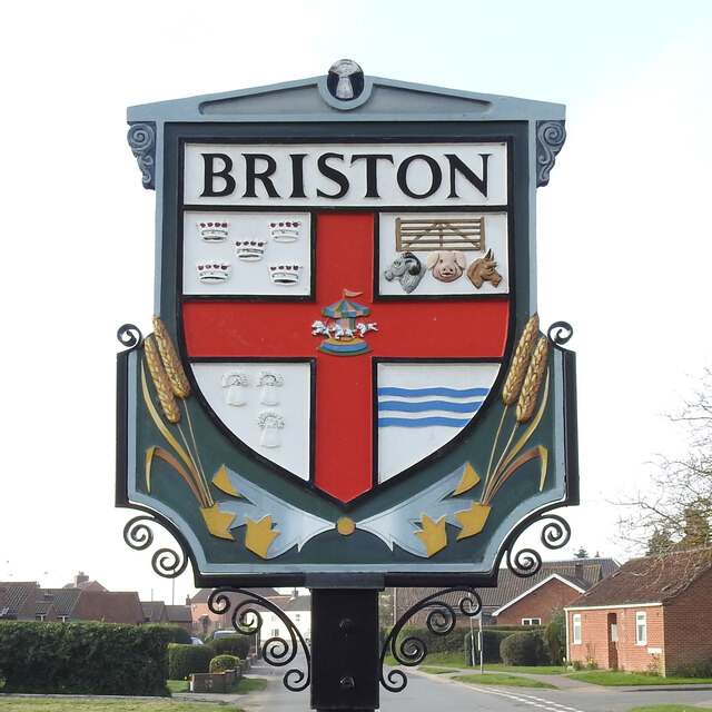
The sign is double sided and identical on both. It is surmounted by a tiny wheatsheaf, and divided into four grounds by a red cross. Top right are five crowns for a reason I have yet to establish. The five bar gate and farm animals and the wheatsheaves below are representing the agricultural heritage of the parish, as are the ears of wheat below the shield.
The River Bure, which is represented by the wavy blue lines, bottom right. In the centre is a merry-go-round reminiscent of the fair held on the village green. Link
The River Bure, which is represented by the wavy blue lines, bottom right. In the centre is a merry-go-round reminiscent of the fair held on the village green. Link
Village Signs of East Anglia
Village signs are typically placed along the principal road or in a prominent location such as a village green or close by the church. The design often depicts a particularly feature of the village or a scene from its history, heritage, or culture. They are typically made of wood or metal or a combination of both, the designs are often made by the local community.
Although they do appear in villages and towns all over the country they are more prominent in East Anglia than elsewhere in the country.
 Map © Crown Copyright")
TIP: Click the map for more Large scale mapping
- Grid Square
- TG0632, 31 images (more nearby 🔍)
- Photographer
- Adrian S Pye (more nearby)
- Date Taken
- Wednesday, 31 March, 2021 (more nearby)
- Submitted
- Wednesday, 7 April, 2021
- Subject Location
-
OSGB36:
 TG 060 328 [100m precision]
WGS84: 52:51.2218N 1:3.5536E - Camera Location
-
OSGB36: TG 060 328
- View Direction
- SOUTH (about 180 degrees)