SJ7581 : Plaque on Airborne Forces Memorial at Tatton Park
taken 3 years ago, near to Rostherne, Cheshire East, England
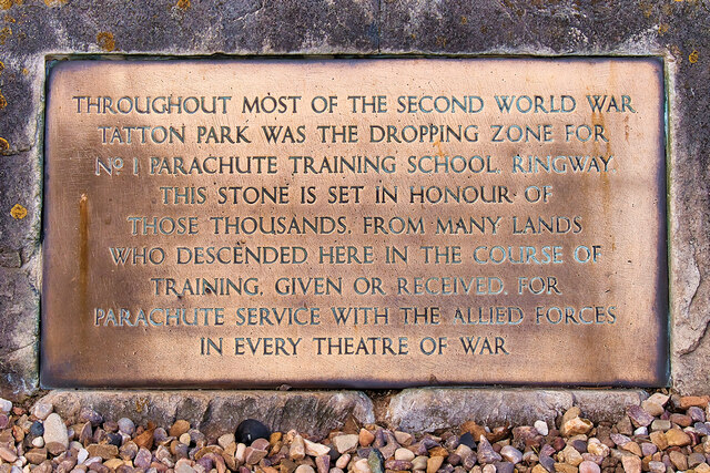
The inscription reads:
THROUGHOUT MOST OF THE SECOND WORLD WAR
TATTON PARK WAS THE DROPPING ZONE FOR
No1 PARACHUTE TRAINING SCHOOL, RINGWAY.
THIS STONE IS SET IN HONOUR OF
THOSE THOUSANDS, FROM MANY LANDS
WHO DESCENDED HERE IN THE COURSE OF
TRAINING, GIVEN OR RECEIVED, FOR
PARACHUTE SERVICE WITH THE ALLIED FORCES
IN EVERY THEATRE OF WAR
Tatton Park is a historic estate in Cheshire, to the north of the town of Knutsford. It contains a mansion (Tatton Hall), a manor house dating from medieval times (Tatton Old Hall), gardens, a farm and a deer park of 2,000 acres. For nearly 400 years the estate was the property of the Egerton family until it was bequeathed to the National Trust in 1958.
One of the most complete historic estates open to visitors, it is now a popular visitor attraction which hosts over 100 local and national events annually include the annual Royal Horticultural Society (RHS) Show, car shows, concerts, courses and craft and antique fairs.
The early 19th-century mansion sits amid a landscaped deer park and is opulently decorated, providing a fine setting for the Egerton family's extensive collections. The theme of Victorian grandeur extends into the garden with its glasshouses, formal gardens, Italian and Japanese gardens.
More information:
LinkNational Trust Visitor Information
Link
 Map © Crown Copyright")
- Grid Square
- SJ7581, 104 images (more nearby 🔍)
- Photographer
- David Dixon (more nearby)
- Date Taken
- Wednesday, 28 April, 2021 (more nearby)
- Submitted
- Saturday, 1 May, 2021
- Subject Location
-
OSGB36:
 SJ 751 819 [100m precision]
WGS84: 53:20.0160N 2:22.4772W - Camera Location
-
OSGB36: SJ 751 819
- View Direction
- NORTH (about 0 degrees)