2021
NY2628 : Dropping down the voie normale south of Skiddaw
taken 3 years ago, 3 km from Millbeck, Cumbria, England
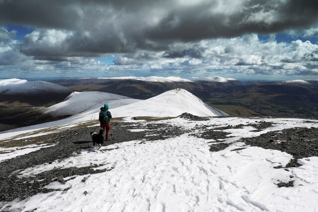
Dropping down the voie normale south of Skiddaw
The tourist route from the south up Skiddaw is rocky for its entire distance, although here in a late spring snow covering the upper slopes are a little more treacherous than you might expect for early May. Ski tracks indicate that a day earlier the route had been in condition for a different means of travel. The photo is taken just as the bridleway starts to descend from the summit ridge towards Little Man, which it will skirt by a very snow-covered path on the northeast slope (seen just to the left of the walker). Ahead in the distance, beyond the eastern outskirts of Keswick, the hills rise again to the extensive summit plateau of Helvellyn.
 Map © Crown Copyright")
TIP: Click the map for more Large scale mapping
- Grid Square
- NY2628, 48 images (more nearby 🔍)
- Photographer
- Andy Waddington (more nearby)
- Date Taken
- Wednesday, 5 May, 2021 (more nearby)
- Submitted
- Tuesday, 11 May, 2021
- Subject Location
-
OSGB36:
 NY 2608 2852 [10m precision]
WGS84: 54:38.7808N 3:8.8214W - Camera Location
-
OSGB36: NY 2606 2854
- View Direction
- Southeast (about 135 degrees)