H4869 : Bloody Bridge
taken 19 years ago, 4 km SE of Omagh, Co Tyrone, Northern Ireland
This is 1 of 9 images, with title Bloody Bridge in this square
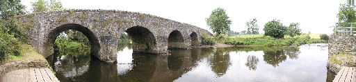
Bloody Bridge
It spans the river Camowen and is between the townlands of Aghagallon and Edenderry, just outside Omagh town. I cannot find any information as to why it is so called, but could be a reference to the stormy past.
![Creative Commons Licence [Some Rights Reserved]](https://s1.geograph.org.uk/img/somerights20.gif)
|
· Find out How to reuse this image ·
Share:
|
|||||
| Start a discussion on H4869 | Suggest an update to this image | Contact the contributor | |||
Loading map... (JavaScript required)
- Grid Square
- H4869, 272 images (more nearby
 )
)
- Photographer
- Kenneth Allen (find more nearby)
- Date Taken
- Tuesday, 18 October, 2005 (more nearby)
- Submitted
- Saturday, 22 October, 2005
- Category
- Bridge (more nearby)
- Subject Location
-
Irish:
 H 485 698 [100m precision]
WGS84: 54:34.4764N 7:14.9644W - Camera Location
-
Irish: H 485 698
- View Direction
- Southwest (about 225 degrees)
Image classification(about):
Geograph
This page has been viewed about 189 times.
View this location:
KML (Google Earth) ·
Google Maps ·
Bing Maps ·
Geograph Coverage Map ·
More Links for this image
·
Bing Maps ·
Geograph Coverage Map ·
More Links for this image