2021
TA1625 : Paull Playing Field from the Air
taken 3 years ago, near to Paull, East Riding of Yorkshire, England
This is 1 of 11 images, with title starting with Paull in this square
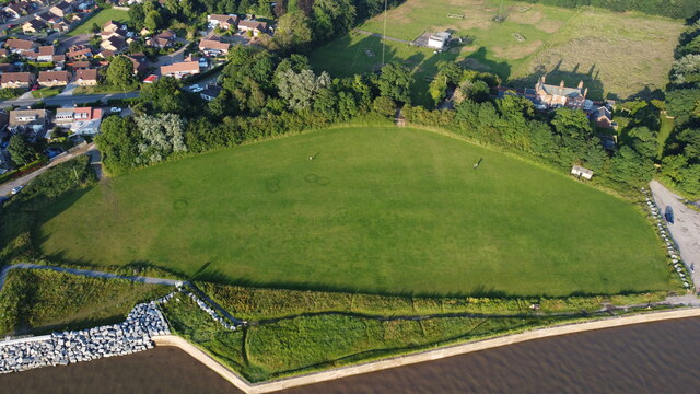
Paull Playing Field from the Air
Taken from over the edge of the River Humber embankment from about 120m high, the photo shows the unusual shape of the playing field. Even stranger, six circles, of roughly 3m diameter, can be seen towards the left of the field where a different, darker type of grass appears to be. Any ideas anyone? Is it 'fertiliser graffiti'?!
 Map © Crown Copyright")
TIP: Click the map for more Large scale mapping
- Grid Square
- TA1625, 97 images (more nearby 🔍)
- Photographer
- Andy Beecroft (more nearby)
- Date Taken
- Saturday, 10 July, 2021 (more nearby)
- Submitted
- Saturday, 10 July, 2021
- Subject Location
-
OSGB36:
 TA 1679 2589 [10m precision]
WGS84: 53:42.9818N 0:13.9049W - Camera Location
-
OSGB36: TA 1664 2587
- View Direction
- EAST (about 90 degrees)