2021
NT0262 : Former Nuclear Bunker near West Calder
taken 3 years ago, near to West Calder, West Lothian, Scotland
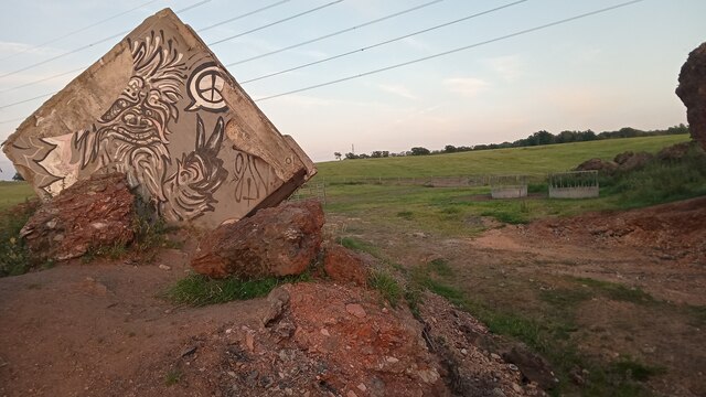
Former Nuclear Bunker near West Calder
Built at the height of the Cold War, and decommissioned only after the fall of the Soviet Union and the Berlin Wall in the 1990s, over a thousand of these structures used to be maintained in Britain. I assume most of them are still in place but as this one was buried in a spoil heap it has been allowed to topple to this position (that hides its entrance) to allow some of the shale mining waste to be taken away to be used elsewhere.
A tall vertical ladder used to lead down into the reinforced concrete block, and whoever's task it was to man the post was provided with enough food and water to last them three days, during which they were tasked with carrying out measurements of the radiation in the atmosphere. To collect the data and measurements they were required to briefly leave the bunker as the monitoring equipment was situated next to the hatch. After the three days were up, they would emerge blinking into the sunshine to report to their superiors. All in all it is probably a very good thing that this rather optimistic operation never had to be called upon!
I can remember the bunker as still being in position in the late 1990s. By then the top of the concrete was already exposed and it was starting to look very precarious, though it was obviously still being used as a drinking den by the local teenagers. The rumour back then, the internet still being in its infancy, was that it was designed to be used for monitoring enemy aircraft in wartime
The CND graffiti makes more sense when its original purpose is known, but I'm not sure why a fearsome looking dragon (or strange looking chicken?!) is making the peace sign.
 Map © Crown Copyright")
TIP: Click the map for more Large scale mapping
- Grid Square
- NT0262, 18 images (more nearby 🔍)
- Photographer
- Ian Dodds (more nearby)
- Date Taken
- Monday, 26 July, 2021 (more nearby)
- Submitted
- Thursday, 29 July, 2021
- Subject Location
-
OSGB36:
 NT 0290 6253 [10m precision]
WGS84: 55:50.7702N 3:33.1401W - Camera Location
-
OSGB36: NT 0290 6253
- View Direction
- East-southeast (about 112 degrees)